Home page: www.treks.org
Table of Contents "On the road to Kabul
and other short stories of treks"
Italy: Appenines
Pizzo d’Intermesoli:
"Best left to walkers with climbing experience". Gran Sasso, Italy,
June 2005.
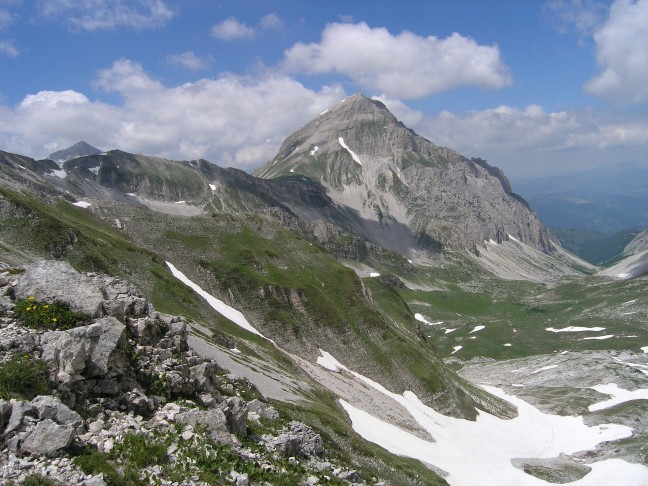
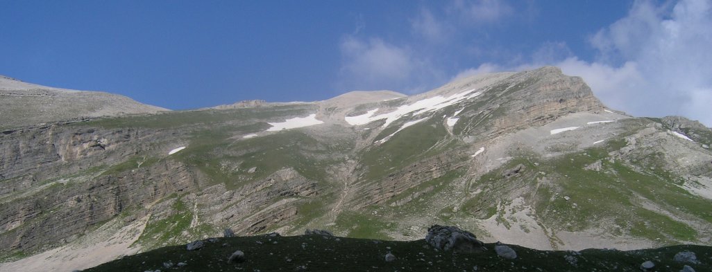
Pizzo d’Intermesoli, 2635 m.
After climbing up the Pizzo
d’Intermesoli, the last 200 m consisting of a mix of very steep scree and solid
rock faces, we were wondering what to do. Going down would be only 45 minutes
but seemed treacherous. We asked an Italian men coming up after us if there was
another way down and if he would go down again. No, he said, “pericolo”, while
waiving his arms.
He was going to continue
along the marked trail along the ridges all the way North, to Pradi di Tivo or
Pietracamela. He seemed to know the way given his very quick pace and kept on
going only stopping for a minute to look at the high peaks around us and
pointing us to a herd of chamois. While disappearing, already at a 50 m
distance, he gave us vague directions to follow the ridge first and go down on
the sloping North-West side of the mountain.
Looking at the vertical
cliffs on the far side of our target valley we were suppose to go down into, I
was wondering. Is there a route down but why is there no trail indicated on the
map. This looked suspicious. A new route to explore, always gives surprises.
Pizzo d’Intermesoli, 2635
m
Going up Pizzo
d’Intermesoli foloowing the 1B route, seemed like a simple walk-up from Sella
dei Grilli at 2220 m but from a distance the last 200 m up looked very steep, if not a grade 4 rock
climb.
From Campo Imperatore, the
pass is easily reachable by three routes. The easiest is along the main ridge,
the number 1 route to Capanne and go up Sella dei Grilli. We took the more
direct crest route following the 1V trail starting past La Portella and
crossing the Sella del Cefalone. This took us two hours going very slowly.
At Sella dei Grilli you
have a magnificent view at the Pizzo and it not only looks very steep, but it
is.
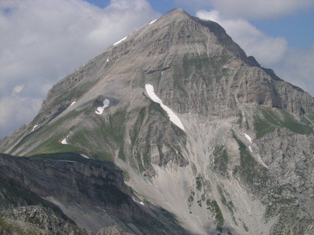
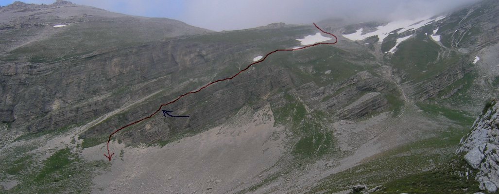
Pizzo d’Intermesoli,
detail of the normal route up, from bottom left at 2220 m at Sella dei Grilli
and straight to the top at 2635 m. Detail of photograph taken near La Portella.
It is only 400 m vertical
meters up and you see a zigzag trail until it disappears on the solid rock
faces and steep scree. Why is this number 1B routes marked as a dashed route
(meaning not too difficult, still a walking route) and not as a dotted route
(meaning for walkers with climbing experience)?
It seemed we would have to
climb across a mix of steep scree and solid rock faces and the ridges could be
even a 4th degree rock climb using the Lonely Planet quote for the
direct route of the nearby Corno Grande, “a challenging scramble, best left to
walker with climbing experience” (Walking in Italy, p. 269).
We decided to go for it. We
could always go back earlier or continue the long marked 1B route along the
crest to Prati di Tivo or Pietracamela, a 3-4 hour walk with an additional 3
hours back to Campo Imperatore.
While studying the route
up, a rescue helicopter was doing touch downs on the Corno Grande which we went
up along the West Ridge 3 days earlier and this now looked like an impressive
ridge walk but we walked mostly in the clouds so we did nor really have good
views down the 500-700 m high South face.
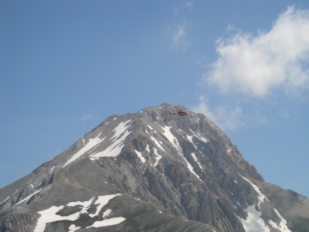
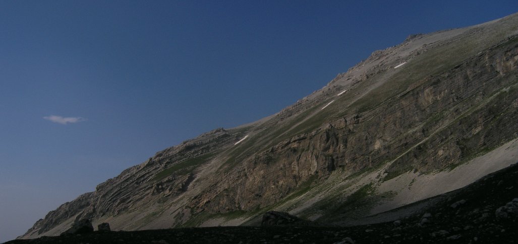
Corno Grande West Ridge
with rescue helicopter practise flight. Norht ridge (right) is 500-700 m high.
It also touched the top of
Pizzo Cefalone we went up two days ago.
. 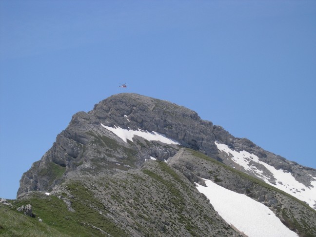
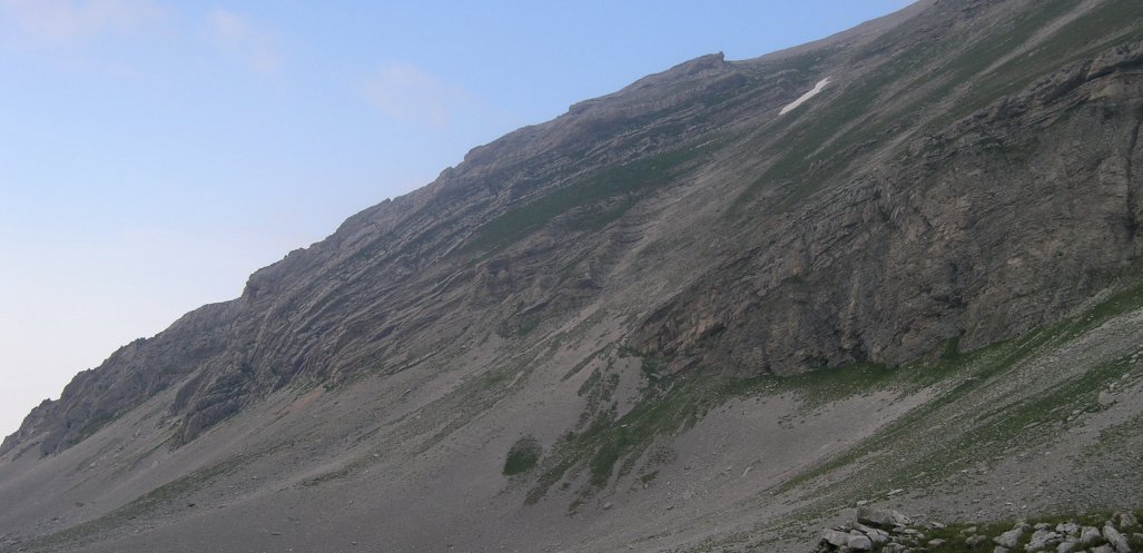
Pizzo Cefalone North
Ridge with rescue helicopter. Low ridge is the Sella de Cefalone.
The North route up Pizzo Cefalone
on the picture above is said to be wiped out by land slides and littered with
slippery loose scree, so we did not try this two days ago.
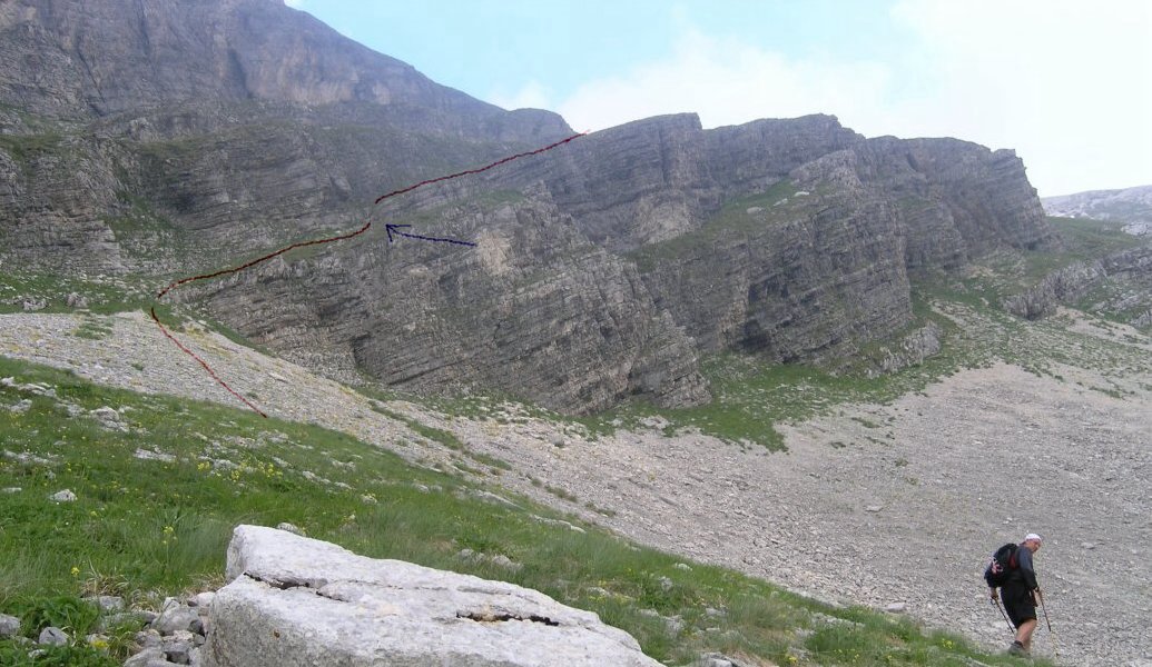
Going up
The first 200 m up route is
easy, a well marked zigzag path goes up on reasonable solid scree. It suddenly
gets very steep when solid rocks started sticking out in between the loose
scree. The last 200 m up is much harder and we are often crawling on hands and
feet holding on to solid rock faces. The yellow/brown markers on the route are
numerous and well visible so you only need to look at a 4-5 m distance to find
the route and you may not even notice you are on a steep slope with loose and
slippery rocks.
At one point there is a 30-40
m 4th degree (60 degree) rock climb going through a small canal. At
this point you should go back if you are and were planning to go back the same
route and feel uneasy on loose scree.
However, there are two, much longer
escapes but these should only be done in good weather, see below.
You need some rock climbing
experience going up a 30-40 m high canal. Standing on the ledges is easy while
holding on by hands for safety but for those who never climb, a rope for
security is recommended, especially going down. The last 50 meters above the
canal to the top are initially a very steep scree slope but it levels out more
and more when you get closer to the top.
On top and going down
On the top you have a magnificent
view at the Corno Grande to the North-East, especially the West Ridge, and at
Monte Corvo to the West, You also see the continuation of the 1B trail to the
North along the crest. The map only indicates a single trail, a 2-4 hour walk
all the way to Pradi di Tivo.
Now you seem to have only
two options, continue the crestal 1B route for 2-4 hours, depending how fast
you are, but you will need 3-4 hours to go back to Campo Imperatore. Going back
down the same route you came up, is only 45 minutes but you need a secure stand
on the loose scree and solid rocks going down, and, even more, no fear of
heights.
Directions
We asked an Italian man in
his late forties or early fifties coming up after us if there was another way
down and if he would go down again the same route. No, he said, “pericolo”,
while waiving his arms in an typical Italian way. He was going to continue
along the marked crestal trail all the way North, to Pradi di Tivo or
Pietracamela. He seemed to know the way given his very quick pace and stopped
for only a minute, pointing to a herd of chamois in the far distance. We asked
him if there was another way down and he gave vague directions to go down on
the North-West side. I saw a possible trail that did not continue. When he was
already at a 50 m distance we asked him again and he told us to follow the
ridge first and go down along the sloping North-West ridges, giving directions
waiving with his arms.
Looking at the vertical
cliffs of Monte Corvo on the far side of our target valley we were suppose to
go down into, I was wondering. No trail on the map, not even a dotted line.
This looked suspicious. A new route to explore, always gives surprises. We were
going to call the new route the “49th Birthday Route” as it was
Ruud’s birthday today. We could always carry on following the long 1B route
along the crest if this failed as Ruud was suggesting earlier: “I am not going
down this route again, no matter what”. However, we would have to stay
overnight in an hotel as it was already 1 PM.
Crest route with
continuation of the 1B trail going North. The new route down from Pizzo
d’Intermesoli is just below the grass of the prominent ridge (extension of the
snow field), following the dip slope.
We followed the crestal
route first till the 2438 m high saddle and had lunch. We saw the Italian men
disappearing in the the distance and he was already close to the second peak,
frightening a few herds of chamois with around 30 animals. This could be
chamois country as it is isolated and there are probably few walkers on this
route.
I had the feeling we had to
go down all the way as far North as possible (far side valley on picture
aboved) as the opposite Monte Corvo has a nice scree slope far North but closer
there were vertical cliffs.
We stayed above instead of
below the prominent ridge going down and went down along snow fields aiming at
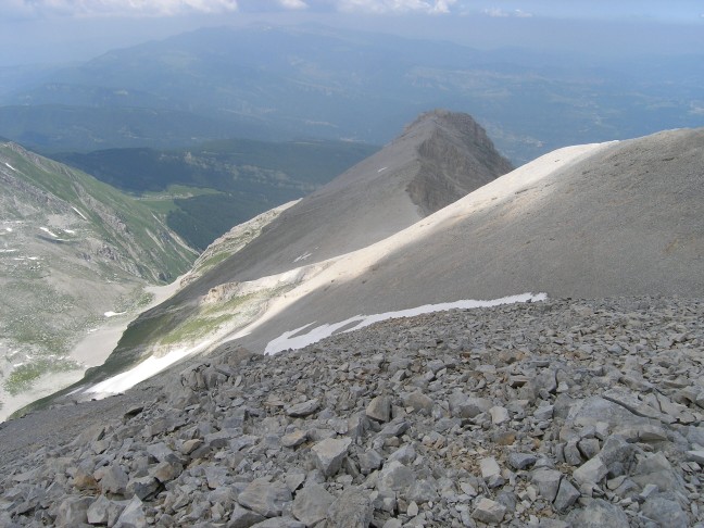
the scree slopes across the valley. This turned out to be the wrong way.
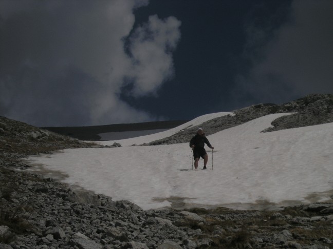
Going down in snow
fields above the prominent ridge, wrong side down.
It looked fine going down
easily for 400 meter but suddenly we were standing on top of 50-70 m high
vertical limestone cliffs. No route down. I could see a scree slope touching
the valley south of the ridge, a clearly safe route, but this would require to
go back up for 300 m and go down again.
We continued North along
slippery scree staying parallel with the contour lines assuming we could go
down along a similar scree slope as visible across the valley. Suddenly, near
what looked like a promising way down, thin bedded limestone was stucking out
of a steeply sloping, soft rock wall and it got scary steep and very slippery,
with little to hold on to. Again we missed 50-70 meters and there was no safe
way down. The valley floor and scree slopes were not visible so there must be
something steeper than 45 degrees behind, another cliff.
Steep North side,
overview, seemed impossible to go down, when standing above.
Steep North side,
detail.
We went back up at a
considerable effort, also as it got very warm due to lack of wind with
temperatures around 23 degrees Celsius. On top of the ridge we moved to the
scree slope below the grassy dip slope (see Crestal Picture looking down,
picture number 5), avoiding the steep snow field, staying below, and cutting
towards the big rock cliff once below the main snow field. On the way down I
saw vague foot steps in several places in the steep scree and we may be on the
right track.
Overview at the Pizzo
d’Intermesoli and the prominent ridge. Route
runs just below the big snow field in the middle and and the two small snow
fields on the left.
Below the big snow field it
is tempting to go left (West) instead of
continuing North-West and on the picture it is not clear if you could go
down (see long valley in the centre above). Going North-West you have a choice
to take the canal right below the main ridge (right) or a canal just below
(left), marked with the last, small snow field on the picture below. We decided
to go left as the right canal did not have a visible continuous slope as we saw
a few hours ago standing on top of the cliff but unable to cross. After 50 m
down there is another choice, left or right. The right canal has a continueous
scree slope and the right one a steep grassy dip slope with a 2 meter high
ledge you can easily climb down.
Route down marked in red, runs just
below the ridge, just below single big and two small snow fields near
middle-top to highest narrow scree slope middle left. Last section of our route
on the ridge just below narrow scree slope, see next picture. 2 m rock climb indicated in blue.
Coming out of escape
route, along the second ledge starting at the highest visible scree slope and
going up to the right on the grassy ledge. 2 m climb indicated in blue.
Down in the valley
We left Pizzo d’Intermesoli
at 1 PM and now it was 6 PM but we were down in the valley. Clouds were
building up. We heard thunder a few times and felt a few rain drops. Going back
to Camp Imperatore was still a long way, 1 hour back the Sella dei Grilli, 300
m back up to the pass, and 2 hours back along the 1V crestal route.
We got back at 9.10 PM,
just before it got dark. The thunderstorm did not hit us but went South.
Epilogue
The next day, we walked out
from Campo Imperatore to Paganica, a 7 hour walk, along the shortest route to l’Aquila.
In the bus from Paganica to l’Aquila, we met a German particle physicist who
worked in the underground lab below Monte Aquila, in the Labaratori Nationali
del Gran Sasso near Assergi.
He was surprised we went up
Pizzo d’Intermesoli as it was know to be a very steep peak. He was interested
to know of a safe alternative route. My recommendations would be not to do the
South route along the marked 1B trail if you feel uneasy doing a 4th
degree rock climbs and standing on slippery, steep scree slopes but go up the
way we came down. This is only 700 meters up but does add 3 hours to the trip
so will be in total 7-9 hours from
Campo Imperatore instead of 5-6 hours. Also, finding your way on a 700 meter
high mountain with steep cliffs on its sides is not easy if you have never been
there, even in good weather. By going up and down the same route you will be ensured of a safe trip.
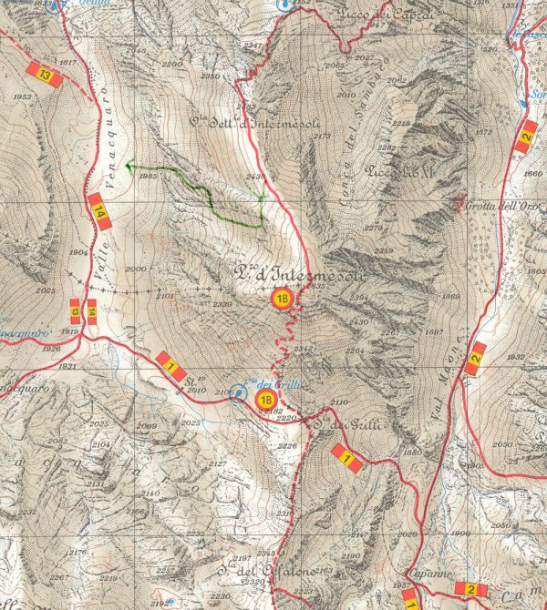
“49th birthday route”
down, in green, North-West of Pizzo d'Intermesoli. Scan of the 1:25,000 map
of the Gran Sasso of the Club Alpino Italiano.
We called the new route the
“49th Birthday Route” as it was Ruud’s Birthday today but
unfortunately we could not mark it with cairns. Hopefully, there are volunteers
we could do this noble work.
Enjoy, and safe trekking.
You are visitor #![]() since July, 2005.
since July, 2005.