Home page: www.treks.org
Table of Contents "On the road
to Kabul and other short stories of treks"
Arthur’s Seat (251 m),
Holyrood Park, Edinburgh
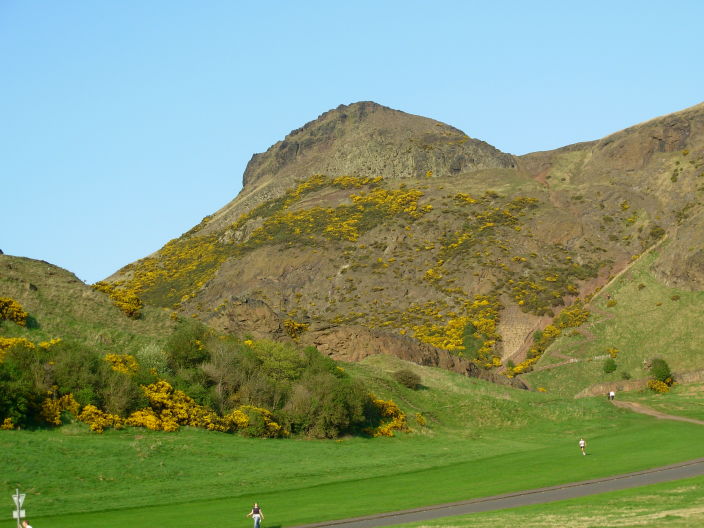
Arthur’s
Seat, view from the South entrance at the Queen’s Drive.
After
running up to Arthur’s Seat, I am now half way at 251 m. A spectacular view on
a rare clear and windless evening in Edinburgh. The run was mostly up for the
last half hour.
Old Edinburgh
Old
Edinburgh is built on a one-mile long East-West ridge of lava some 50 to 70
meters high. Most of the buildings are from past 1767 when Edinburgh rebuilt
the old town, see description in [1]. It still looks
like a fortified city with high
buildings on the ridge side. The old castle was built on the highest point of
the ridge on the West side and dominates
the sky line of Edinburgh.

Edinburgh castle. View from the Apex European Hotel roof top restaurant on the Grassmarket.

Old buildings on the ridge near the castle.
In the
summer, the castle is open from 9.30 AM to 6 PM, with the last tour at 5.15 PM.
Being on a business trip, I missed the openings hours.
Holyrood Park
On the
South-East side of the ridge, near the Queen’s Palace and the Scottish
parliament buildings, there is an even more interesting land mark, the lava
flow hills of Holyrood Park.

100 m high lava flows of Holyrood Park, view South from the Scottish Parliament buildings.
You can
already the lava flows in the distance standing on the bridge East of Waverly
Station but few tourist go there as it outside the city.
The park is
about two km across and is dominated by Arthur’s Seat, at 251 m the highest
point. It is a favourite walking and jogging area with numerous official and in-official
trails dissecting the park. Doing a big loop walking including the highest
hills, will take you 1.5 to 2 hours.
Some
die-hards run the same route but most joggers, generally female students from
the nearby university, use the circular Queen’s drive, a 6 km run. The Lonely Planet Walking in Scotland guide has
a good map of the area.

Another one
is from, see below: http://www.mirang.nildram.co.uk/OurSite/Assets/newwin/map.htm

Holyrood Park in the mist
The first
day visit on Sunday night was in typical Scottish weather, 10 Celcius, misty,
change of rain, strong winds.
Starting at
Holyrood Place, I went up the Salisbury Crags using the small trail (see above,
in grey). Edinburgh Castle was faintly visible in the cold mist.

Edinburgh Castle in the mist.
I continued
up to Arthur’s Seat (251 m) using the steep SW trail (not on the map) which
starts with a good staircase.

Arthur’s Seat in the clouds. Stair case right, easier trail going left. View from the South-West.
It was cold
and windy on top of Arthur’s Seat and the clouds thickened to a complete
white-out.
Going down
I wasn’t sure where I was going, unable to see more then 10 meters. Following a
long grassy slope down, I ended up at Dunsapie Loch, an old volcanic vent. An
ideal trail to go back up running.
Going North
and West I reached the entrance again.
The walk
from the start of the park took some 1.5 hours plus 20 minutes each way to go back the to the hotel
at the Grassmarket.
Running the trails of
Holyrood Park
The weather
changed to unusually nice weather this week, 16 Celsius with clear blue skies
and no wind.
I did a reconnaissance with Chima [1], walking leisurely across the hills
and visiting the only remaining building, a derelict chapel from the 16th century. Old chaple in Holyrood Park. Most runners were doing the 6
km loop, the Queen’s drive, and very few were tempted by the hills. 
I started
at the North Entrance and followed the main loop to Dunsapie Loch, going up
most of the time. It was very busy with joggers.
Past the
loch, I followed the grassy trail up and continued all the way up to Arthur’s
Seat. The last 50 m up is not easy as the trail is steep and has loose gravel.

Last 50 m up, with Chima posing
After a
rest on top I went down to the South-West following the trails and continued along the asphalt of the
Queen’s drive (West side).
The total
run took about 45 minutes.
A more
challenging route would have been the one marked in red on the map above but
this has a lots of loose gravel so is harder on the ankles and foot soles.