
Mount Cook, 3688 m, view North from the Hooker Valley.
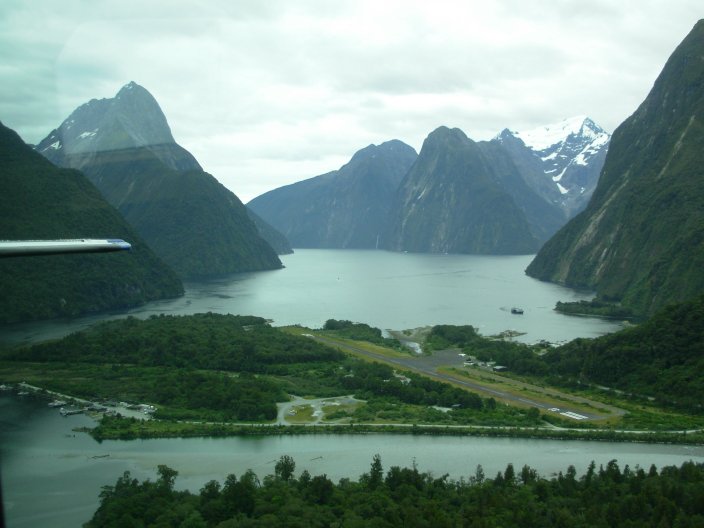
Milford Sound with airport, view North from the aircraft.
Queenstown is the center for treks (or tramps) on the South Island.

Click on map to enlarge. [satellite image, after Google Earth]. [Detail around Queenstown].
With buses going in all directions a few times a day, it is only 2-4 hours to the start or end point of a trek, some 100 to 200 km.
A car is not necessary if you make Queenstown your home base, storing excess luggage in a hotel or backpackers lodge when you are on a trek. All the other towns are tiny, even Te Anau or Wanake, and are less suitable.
If you prefer rural lodges or a camping, a rental car is a must, but beware, sand flies like the country-side as well. Only sufficient car exhaust keeps them out but even in Queenstown they are around at night and try to sneak into the room waking you up after causing an itchy bites. One good advise, don't scratch!
I very much appreciated two-day rests in Queenstown where you could count the final score of sand fly bites without getting new ones.
Sand flies remain the talk of the trekkers, less so then the common rain. When walking on the trails you barely notice them, even when sitting down. However, they love the trekking huts and are extremely common in the lower country of the Fiordlands thriving in fresh puddles of water. Around an outside tab of a hut, they will be after you in clouds and we seem to be their game, also on the nearby rivers and lakes. One minute is all you get for a wash.
They sneak inside the hut when opening a door and a few dozen will cruise near the floor and look for bare ankles. They also visit you at night while sleeping. The best defense at night is a mosquito net.
30 or 80% DEET like in Bushmen's works well but is very sticky. I preferred 30% Care Free which is non-sticky.
Some locals use Dettol that smells like gasoline and mix it with sunscreen. It does work but now you smell like an old tractor..
The sand flies remain very annoying and it is wise to plan for them, starting with a trek with huts at high altitudes where they are less common, to build up resistance against numerous bites and to get into a mind set of “do not scratch that itch”. There may be less in February or March but an added benefit is that the weather may be more stable.
The Fiordlands on the SW coast has very extreme wet weather with 200 rainy days a year and some 11000 mm of precipitation, whereas Queenstown, only 100 km inland, gets only 1100 mm. Parks around Mount Aspiring and Mount Cook also get much less rain sitting in the rain shadow behind the so-called "continental divide" of the South Island. Less rain implies less sand flies.
This year we decided to do a major investment in anti-rain equipment. Boots with Gortex liners (Meindl Burma), light weight rain coat (any brand, I used a 300 gram North Face) and rain pants with side zippers (Patagonia, to reduce sweating by opening the upper zippers), small waterproof stuff bags of “Sea to Summit”, a 70 liter light weight inside ruck sack liner from “Sea to Summit”, a bunk bed army mosquito net, and light weight gaiters (unfortunately, ours did not cover the flaps with shoe laces completely so the rain slowly flowed).
Other successful equipment were Odlo thermal undies (non-sweaty and dry in a minute), Icebreaker Merino shirts (bought in Queenstown, expensive, do not attract dirt), carbon fiber ski poles (three times less weight), “clickthatitch” against itchy bites (uses an electric pulse), and the very clean, non-smelly 30% DEET from Care Plus ( Bushmen 80% stinks and is sticky).
The Gortex boots worked fine but need shoe grease every morning as they usually get wet during the day, also when it is not raining. There is always wet grass in the morning and every day you will go through puddles of water, mud and a few shallow streams.
A lightweight Karrimat should always be brought in case a hut is full and you will have to sleep on the ground.
The Milford Sound and Kepler treks are relatively easy and very scenic and unfortunately are very popular, with hut crowds of some 50 people. They require advanced bookings.
If this does not appeal to you try the more challenging Holyford Trek (intermediate) with the very slippery Demon trail or the infamous Dusky Trek (advanced), known for potentially waist deeps floods in two areas you may have to sit out for one or more days. Both routes attract few people, estimated 2-4 every one or two days.
Other treks are the 3 Tuatapere Hump Ridge trek on the South Coast and the 11 day Steward Island trek. The latter is said to be very muddy but this is probably the only place in New Zealand where you (could) see the rare Kiwi bird, New Zealand's national symbol.
National Geographic has a story on the Holyford Valley in the December 2000 Issue, also see [1] [2].
Guided three day tours are offered by a commercial company [1]. The site has nice pictures.
The Routeburn Trek is the very popular and requires pre-bookings, 1-2 weeks ahead of time. All the other treks are freely accessible. Most popular are Rees-Dart, Caples, Greenstone and Gillespie Pass. The North - South crossings of Cascade Saddle/Pylon and the Rabbit Pass, both near Wanake, are Alpine crossings and require an ice-axe and crampons for the steep snow fields until very late in the summer. Rabbit pass also requires a tent for at least one night.
The Mount Cook area has the 1-3 day Mueller hut trek and the 2-3 day Ball Pass Alpine route which runs close to the base of Mount Cook.
Mueller Hut
Mueller Hut is an intermediate route as it includes a 100 m steep slope of mixed scree and snow. The rest is easy.
Ball Pass
Ball Pass is an Alpine route with a few 4th degrees rock climbs and two small glaciers with crevasses. It requires an ice-axe and crampons, especially later in the season when the snow is gone and bare ice appears.
The fliers from DOC suggest a South to North crossings, a 10-12 hour trip from the village to the Ball Shelter. As the Caroline's Hut is a private hut and locked, it would be best to camp in the Hooker valley first before crossing to the Ball Pass Shelter shortening the day by at least 2 hours. In case of emergency you could camp next to the Caroline's hut, the only area with a descent flat area.
Crossing the Ball Pass from North to South should only be done with a mountain guide as the route is not marked and intuitively you will probably end up too low unable to go down the steep walls of the main valley. Gottlieb from Alpine Recreation offers a 3 day trip using his Caroline's Hut and you get close to Mount Cook, the Tasman Glacier and Hooker Glacier.
Alternatively, if you do not have a tent, you could do a return trip from the Ball Shelter Hut to the Ball Pass, only 6-7 hour. You will have close views at Mount Cook. This is very suitable for advanced trekkers as long as you stay off the glaciers given the numerous dangerous crevasses and follow the rocky ridge. People have disappeared in this area.
Copeland Pass
The classic Copeland trek starting at the West coast is destroyed by land slides at the moraine in the Hooker valley, the last day stretch, and the 6 bunk Hooker hut below the Copeland Pass is not accessible anymore.
It can now only be done with the help of a mountain guide through the Fitzgerald or Copeland Pass now starting in the Mount Cook area and going to the coast.
In the past trampers coming down from the Copeland Pass towards the Hooker hut, would hit a last, few 100 m deep spur known locally as the "valley of death".
The Milford Sound trek is the only one you need to book months ahead via the Internet. Kepler and Routeburn can be booked in a DOC office or on the Internet only 1 or 2 weeks ahead. On all the other treks, huts cannot be booked and they are rarely full but you should bring a light foamy or so-called Karrimat just in case you are unlucky to hit a group.
The Mueller Hut near Mount Cook can only be booked locally at the DOC office and space is not a problem except perhaps during Christmas and you could book it the day you go in or the next day.
Huts can get very crowded when the weather is poor. The high altitude Mueller Hut occupation exploded from 28 (capacity) to over 40 people when we were there. If you stay another night without a booking you will be on the floor. Bringing a Karrimat is always recommended.
We did the 5-day Rees-Dart trek in Mount Aspiring National Park as a warming up, the 6-day Caples-Holyford trek as a Fiordland trek with potentially lots of rain and sand flies, and finally, in the Mount Cook area, the 1-day Mueller Hut and 2-day Ball Pass for a high Alpine mountaineering experience.

Mount Aspiring, 3033 m, view from the Cascade Saddle, 1524 m.
Summary
(to be completed)
Description
The Rees-Dart trek is a 5 or 6 day trek near Glenorchy.

Rees and Dart valley (top centre,day 1-5), Routeburn (centre, not marked), Caples Valley (bottom centre, day 1-2) and Holyford Valley (top left, day 3-5). After Google Earth (maps.google.com). Click on map to enlarge.
Going anti clock-wise starting in the Rees Valley is recommended but the first day is very long, 5-7 hours walking time, with a rough and muddy final 2-3 hours trail through the forest. If you start in the Dart Valley going clock-wise, the first two days are much shorter, only 4 -5 hours, and the track is much easier.
Highlights are the very comfortable Dart Hut on the second day that can be used for an day trip to the Cascade Saddle (7-9 hours) with views at Mount Aspiring and the Dart Valley Glacier. Another scenic route is the crossing of the Rees Pass from the Dart Hut to the Flat Rocks Hut. Near the Cascade Saddle there is a very nice camping area attracting 1-4 campers a night and from here it is only 30 minutes to the saddle to see Mount Aspiring at sun rise, with the best change to get a clear view.
A low light are the noisy Jet Boats on the Dart River on the last day below the Daleys Flats Hut, sold as a New Zealand adventure.

Rees valley. Near drop-off point.

Shelter Rock hut.

Happy New Year on the Rees Pass, 1471 meter, at New Year Central European Time, 0.05 h.
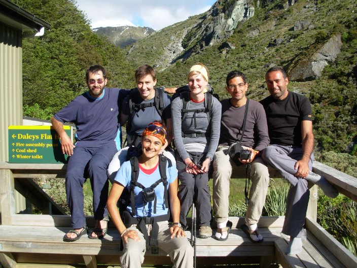
Three Israelis boys and three Swiss girls (Martine, Simone and ...).

Flats below Dart Hut.

Yogini Carol (back) with daughter (front) in the Dart River Valley at the Daleys Flat Hut. Also see [1] and [2]
What is the meaning of life? Yogini Carol asked us. I looked at her daughter and thought, "Pass it on and enjoy while doing this”.

Jet boats (left corner, see detail) on the Dart River near Chinamen's bluff.

Jet boat on the Dart River below Chinamen's bluff at the parking lot.
Other Photos
Flat Rock Hut Flat
Rock Hut
Distance from Flat
Rock Hut to Dart Hut and Muddy Creek
Rees
River below Rees Pass.
View from
Rees Pass to Dart River.
Flowers.
Route between Rees Saddle and Dart
Hut.
Dart Hut
Warning
for route past Cascade Saddle.
Dart
River Glacier, view South.
Dart
River Valley, view North.
Glacier
South of Cascade Saddle.
Japanese
walker.
Martine, one of the
three Swiss girls.
Simone, one
of the three Swiss girls.
One of
three Swiss girls.
Glacier
South of Cascade saddle.
Cascade
Saddle and the Pylon Pass.
Good
camping place South of cascade Saddle.
Dart
River Valley.
Crossing one of
the side streams.
Barren
areas along the Dart River (flloods?), South of the Dart Hut. View
North
Mist at the Daleys Flat Hut
in the early morning view North.
Milford Sound with airport, view North from the aircraft.
Summary
“Who are you flying next?” We asked our pilot that flew us out from the head of the Holyford Track at the Martin's Bay lodge on the coast to Milford Sound. “Oh, a few more stinking old trampers”, he said with a sly smile and started filling up the gas tank.
Description
The classic Holyford trek can be done from South to North or reverse. To my surprise, it is not very popular, only 2-4 persons per day stay in each hut, but I would soon find out why.
It can be combined with the Routeburn, Greenstone or Caples Treks, adding 2 or 3 days by booking a ride from the Divide on the main Milford Sound Road from Te Anua near the Howden Hut to the start of the Holyford trek. Alternatively, from the Howden Hut you could carry on to Gun's Camp for an overnight stay in the cabins and skip the crowded Howden Hut that requires a booking. From Gunn's Camp you can get again a bus or walk 8 km along a quiet low-land road.
We took the Caples trek which has an easy the first day but the second day across the 945 m high pass (McKellar Saddle) is difficult. The trail is steep in places, very rocky, wet and muddy by wash-outs, and this is clearly an intermediate route. The alternative is the easy Greenstone trek.
From the Divide a bus can be booked for 12.00 h to take you to the start of the Holyford trek.
The Holyford Trek is a low-land trek and now you enter the real Fiordlands, with lots of rain and sand flies. All huts are in excellent shape. Hidden Falls, Alabaster and Hokuri were rebuilt in 2005. Aournd the huts, the sand flies will be after you in clouds. The forest had few sand flies during they day but we had excellent very warm (23o Celsius) weather. The sand flies also keeps the trekkers out, with only 2-4 passing by each day, even on the easy trail from the Holyford Road to the Alabaster Hut.
Between the Alabaster and Hokuri Huts the trail is very rocky in places by numerous wash outs, covered in wet moss with puddles of water or mud, requiring at least intermediate tramping skills. Advise is to go slow on this old cattle trail that is not anymore maintained, and use walking sticks as you will slip a few times. Walking times mentioned on the signs are very generous. DOC did fix up really bad portions recently and also added four crucial three-wire bridges. Now you will not get stuck when the rivers are high by recent rain falls, a risk still mentioned in many guide books like the Lonely Planet.
Flying out from the Martin's Bay lodge to the scenic Milford Sound is an absolute highlight. Costs are steep, NZ $ 455 for a chartered four-seater plane with Air Fiordland, but you have flexible flying times when booked in advance. We left 2 days earlier and this was no problem.
The reverse direction is cheaper, only NZ $ 110 as many flights are empty with most persons flying out. You can also take a plane from Gunn's Camp but these are much less frequent and now you would miss the Milford Sound scenic flight.

Lake Wakatipu, across start/end of Greenstone/Caples Trek, view North-West.

Holyford valley, view North.

Wire bridge, start of the Holyford trek.

Hidden Falls hut.

Lake Alabaster.

Pike River wire bridge near Alabaster Hut.

One of the four tricky “three wire” bridges between the Demon Hut and Hokuri Hut.

Three wire brigde with firns.

Hokuri hut with window screen full of sand flies.

James Town, an old settlement from late 19th century. Only a few apple trees remain.

Lake McKerrow, view South. View South into the Holyford Valley from near James Town

Giant ancient tree.

Giant ancient tree.

Martin's Bay lodge with the Air Fiordlands aircraft.

Holyford valley view South with McKerrow Lake and Martin's Bay Lodge (mid-left). View from the aircraft.
Other Photos
Caples Valley, view South.
Rough
track North of Caples Hut.
Same.
View East from the McKellar Saddle
(945 m)
Greenstone Valley.
Greenstone Valley.
Distance
sign in the Greenstone Valley.
Howden
Hut.
Distance from Hidden
Falls Hut.
Hidden Falls.
Plague for Mr. Gunn.
Pyke
Lodge, near Alabaster Hut.
Alabaster
Hut.
Distance near McKerrow
Hut.
Trees between
Alabaster and McKerrow Hut
McKerrow
Lake, view South.
Three wire
bridge with firns.
McKerrow Lake,
view South.
Hokuri Hut.
Old
fallen tree at Hokuri River.
Tree
bridge across Hokuri River.
McKerrow
Lake, view South.
West Coast with
sand banks and McKerrow Lake, view South-East.
Milford
Road near tunnel with waterfalls.
Sheep
near te Anau.

Mount Cook, 3688 m.
Summary
“I have a sour throat”, Ruud said. Gottlieb, our mountain guide responded: “I think you are dying. Men your age suddenly drop dead.”
Near the end of the Ball Pass crossing, close to the village, Gottlieb said: “We are close to the perfume track”. Within minutes we spotted dozens of tourists on the short route from the village to the Hooker Glacier lake; many were Japanese. These were the first people we met since we left the Ball Shelter Hut yesterday.

Mount Cook area satelite image. After Google Earth (maps.google.com). Click on map to enlarge.
Mueller Hut.
The Mueller Hut is a normally an overnight trip but you can also do it in one day, with 5-7 hours net walking times. Given the Alpine landscape with barren rocks and glaciers, you need a mountain guide to go much further on day trips.

Mueller Hut, 1830 m altitude.
Ball Pass
We hired Gottlieb of Alpine Recreation, also to be able to use his privately owned Caroline's Hut. This is an Alpine crossing with steep snow fields and a few short 4th degree rock climbs. The route is poorly visible, cairns are absent.
A 3 day trip with Gottlieb is highly recommended which gives you a two-day stay at his private hut which is an absolute beauty on a perfect location with views at Mount Cook. You also get a change to go up to some of the lower peaks and do some rock and ice climbing.
From end of a very rocky 4WD road next to the Tasman Glacier it was only 45 minutes to the Ball Shelter, a 6 person hut. We used an old Toyota 4WD to drive this portion. Normally you would start from the car park at the head of the Tasman Glacier and the distance to the Ball Shelter is about 8 km or normally about 2.5 -3 hours walking time.
From the Ball Pass Shelter to the Caroline's Hut is 2-3 hours and the route goes steeply up to the ridge and once you are up it follows the ridge crest. It is rough and only experienced trampers should do this on their own, also as the route has very few marks.

Hooker Valley with Mount Cook (far left).

Ball Pass and the Hooker Valley.

Caroline's Hut.

Caroline's Hut.

Ridge towards Caroline's Hut (bottom right)

Ball Pass, South side.

Ball Pass, South side, going down into the Hooker Glacier. Route stays high.

Ball Pass, South side.

Hooker Glacier and Mount Cook.
The Grand Traverse and Mount Cook
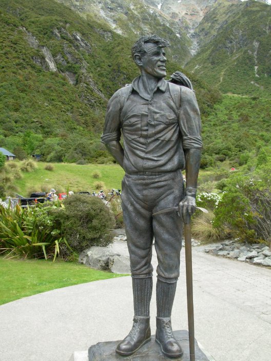
Hillary did the Grand Traverse of Mount Cook, a route along the ridge, in 1970. His statue at the village has been modeled after a picture taken right after he came down from this trip.
Mount Cook is only 3688 m high but classified as an intense mountain climb. It takes only a single, very long day of some 16 hours from the DOC Plateau Hut which is usually reached by aircraft. Walking to the hut is possible but normally avoided as you have walk on the very rough and tricky (by crevasses) Tasman Glacier and climb up a steep route from the Glacier to the hut.
For Mount Cook you need a personal mountain guide given the steep ice, snow and rock faces with a high risk of avalanches. It may seem low, only 3688 m, but is clearly an advanced climb, more difficult than some 8000 m mountains like Cho Oyu. Six day guided trips are offered for 3600 to 4800 NZ dollars. Summit success is some 80% if you are an experienced (also in ice climbing), very, very fit mountain climber. Unlike the high mountains in Nepal, the low altitude of Mount Cook requires ultimate endurance.

Hillary looking at Mount Cook. He did the Grand Traverse in 1970.

Mount Cook area, view from the main road.
Other trips
Most trips in the Mount Cook area are mountain climbs and glacier crossings. Several are offered, popular are those near the Tasman Saddle Hut. See:
Other Photos
Mount Cook
Sir
Edmund Hillary
Mount Cook
Village.
Same, detail.
Steep 100 meter to Mueller
Hut.
Kea at the toilets of Mueller
Hut.
Kea, detail.
Rain
near Caroline's Hut.
Nazomi
(2925 m) and Gottlieb.
Nazomi
(2925 m), East side
Caroline's
Hut.
Large Lychen.
Rough
trail along the ridge to Ball Pass.
Ball
Pass, North Side. View South.
Lake
Tasman, head of the Tasman Glacier.
Ball
Pass, South side. View North.
Hooker
Valley.
Copeland pass, bottom
Hooker Hut, now inaccessible.
Route
up from the Hooker Valley.
Mueller
Hut ridge.
Waterfall with
Gottlieb's garden.
Same.
Same.
Same.
Same.
Same.
Same.
Mount
Cook, from the plane.
Same.
![[satellite image, after Google Earth]](07nz_south_route.jpg)
![[1]](07nz1837carol.jpg)
![[2]](07nz1838carol.jpg)