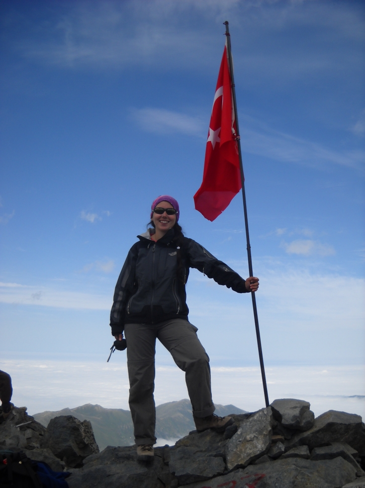
Pelin, student mountain guide, Turkish “Marianna”, on top of the Kaçkar Mountain, 3932 m. 20 Celsius. View at the Black Sea, covered in clouds.
On the top of the Kaçkar Mountain the temperature was a balmy 20 Celsius and no wind. The Black Sea side was covered in clouds and some high clouds were developing in the distance and these had an unfriendly a dark gray colour and looked threatening. Vertical streaks came down from the clouds, typical of active rain clouds.
We went down and within 30 minutes it started, rain mixed with hail stones and a strong wind. Temperature dropped to 4 Celsius. The weather can change rapidly in the mountains.
From Erzerum, it is a 3 hour drive North to the city of Yusufeli, the start of the access road into the Kaçkar Mountains. Close to Yusufeli, the biggest city in the area, the landscape changes from a dry and brown rocky dessert into a dark green area with green meadows and pine forests, as if you are suddenly back in Central Europe.
This is the “rain forest” area of the Black Sea where warm and moist air rises up into the mountains causing rain. When we arrived in Yusufeli it rained.

Pelin, our guide, looking for some information in the Lonely Planet.
The access road into the mountains from Yusufeli to Barhal and the end point at Yaylarlar is a one lane road and our mini-bus took up the full width of the road. Luckely the bus had double back-wheels and at one point we really needed this. At a road wash-out on the cliff side, we felt a little drop and heard cloink. The bus driver accelerating to get out. Other wash-outs were passed unnoticed, the weight resting on the inner wheel.
Views are spectacular, green meadows and orchards between high mountains, rising up 500-1000 m. Many villages still consist of old wooden houses with the stable on the ground floor and the living area above. Access to villages a across the river is often only by cable lift.
Remnants of stone forts illustrate a rich medieval past. The Kaçkar Mountains are just off the main cross-roads of Central Asia and such high mountains with deep valleys are an ideal stronghold.
Most people are of Georgian and Armenian descent, with more typical Caucasian faces, less Ottoman or Turkish looking which were originally from Central Asia.

Barn next to the lodge at Barhal (1200 m).
The first five days we would make a trek through the mountains from Barhal to Yaylarlar, mostly between 2000 and 3400 m. After this would would climb the Kaçkar Mountain (3932 m).
The weather of the first day was abnormal, we thought. Around noon, just before lunch, it started raining. Temperature was down to only 10 Celsius.
We skipped the detour to the lake and took a short-cut, partially cross-country through the bushes and on loose rocks, to the camp. Rain continued at night.
This was not a good start, at 2500 m elevation and only 10 Celsius, it is not what you would expect in Turkey.

Side road up from Barhal. Dark rain clouds in the distance.

Route up from the side valley of Barhal to the first camp, day 1.

Same.

Same.

Unhappy trekker in the cold rain.

Pelin's lonely tree, close to the first camp at Satibe.

First camp at the Satibe meadows/ridge, with a complete rain bow, from left to right.

Horses at the first camp.

Shepherd's dog and horses at the first camp. Dog was threatening me. Later on it bit one of the horse-men.
The second day was much better, 18 Celsius, sunny. We went down along a narrow trail, in part it was washed out and you had to take care. The horses took a longer, more secure route.
Views were spectacular, we passed a few
villages, partially deserted. Bear droppings gave us the feeling we
were in a truly natural area.
Route on day 2, along the gravel road on the right. Next camp is at the end of the valley.

Poppies in a deserted field.

“Flowers are a girl's best friend”.

Horses transporting the camp.
The camp was close to a village that seemed deserted. Taking a bath in the river, I was suddenly surprised by kids coming down from the village. This was a quick bath anyway, 10 Celsius, windy, water near freezing, just a few bottles of water sprinkled on the body but it did clear off the sweat and was very refreshing. “One bath a day keeps the sweat away”.

Camp 2 at 2100 m, breaking up. Village of Pisenkaya in the back ground.

Same.

Same.
The third day we had to cross a pass of 3100 m. Now high up the going was more difficult in the rocky terrain and by the thin air of the high altitude.

Between Camp 2 and 3, going up.

Between camp 2 and 3, looking back to camp 2.

Group foto, while going up. Left to right, top: Jaap, Ruud, Peter, Jean, Patrick, Larissa, Toon, Antoinetta, Hein and Wouter. Left to right, bottom: Theo, Pieter, Jannie, Anton, Pelin (mountain guide) and Remco (mountain guide).

Between Camp 2 and 3, the “tail group” enjoying the views and flowers.

Horses with our camp between camp 2 and 3.

Just a few of many flowers, around 2800 m.

Lake at 2900 m, near the pass. Some of us are warmer then others.

Lake at 2900 m, near the pass. Some of us are warmer then others.

Camp 3 near Satelef at 2250 m.

Camp 3 near Satelef at 2250 m. View towards Bulut Mountain (in the coulds, left).

Camp 3 near Satelef at 2250 m. View towards Bulut Mountain (in the coulds, left).

Water spring of the village of Satelef at 2250 m. View towards Bulut Mountain (center).

Satelef village at 2250 m. View towards Bulut Mountain (center).
Bulut mountain is 1150 m up from the Satelef camp, a roughly 7-8 hour trip.
We went up slowly up and it was relatively cold. In side valley above 2800 m there were snow fields and the going on the loose boulders was difficult. The trail disappeared and there were no marks or cairns on the loose boulders. Any of the boulders, including the big ones, could move, especially at steeper sections. Once a big boulder, activated by us, came rolling down, threatening one of us.
Near the top and in a dense mist, we decided not to do the last 100 m as it was again covered in loose boulders.
Very few people seemed to go up this mountain. There were no signs beyond 2800 m.

Bulut Mountain, 3400 m.

Around 3000 m, seat sheltered from the wind.

Pelin, mountain guide, caressing the warm thermosflask.
From Satelet to Yaylarlar, the end of the access road, is only 2-3 hours.
View are again spectacular, 1000 m high mountains covered in pine forests.
Yaylarlar has a bus station and shops, the first shop we saw in 5 days.
We had lunch in Olgunlar, a choice of local trout or a spongy dish of eggs with tomatoe. This soup like local speciality of eggs and tomatoes was not appreciated by the group. The trout from the river was fine.

View at the main valley (left to right) between Barhal and Yaylarlar.

Bee hives past Satelef.

Bridge past Satelef.

Main valley between Olgunlar and Kaçkar Base camp at 2800 m.

Main valley with a deserted village of Avelgut Y between Olgunlar and Kaçkar Base camp (Cagil T) at 2800 m.
The Kaçkar is the highest mountain in the area and very popular as it is easy accessible.
From Satelef, the end of the access road, it is a 4 hours walk along an easy trail to reach base camp at 2800 m. You could also approach it from the North or South but the trails are harder and longer.
There were some 50 people in the base camp, 7 or 8 different groups. All the young people were Israelis and they had minimal equipment.
With so many people and several pack horses, the toilet access and water supply is problematic. The permanent toilet could not handle the volume dumped. Most trekkers decided to go up hill between the rocks, with plenty of space and pristine spots. However, you should cover your droppings with a stone to make it invisible but such good mountaineering manners, essential in rocky terranes, haven't penetrated yet in this area.
Horses pose another problem. The water run off in the valley takes along manure so drinking water should be taken upstream, a 300 m walk. This happen to be also the area with big rocks with cover, ideal for taking a full body bath. Trekkers returning from the top would be the only surprise visitors but traffic is minimal and mostly around 3 to 4 PM.
We got up at 3 AM (oh no, Pelin said, why so early!) and left at 4 AM. Sun rise was at 4:30 AM. The trail to lake Deniz Golu at 3400 m is easy, slowly going up and frequently used. The lake has a few camping spots but few people use it. At this altitude it is much colder at night. You may also get hit by high altitude sickness which normally starts at 2800 m.
Past the lake the trail was a mix of loose rocks, gravel or solid rock and you soon reach a view point where you have to go down around 100 m before going up again. Following the trail is not easy, there are several side trails but the right one is clearly marked with cairns. As cairns were always present at short intervals, you could tell this is a popular trail.
The trail has only a single difficult passage where you have to climb up 2.5 meter grade 4 ledge, next to a steep drop.
We arrived on the top at 10:30 AM, in 6.5 hours. This was at an easy pace with lots of rests. Given the high altitude, this is recommended.
Temperature was a balmy 20 Celsius and no wind. After the previous days of 10 Celsius, windy and occasional rain, this was totally reverse of what we expected.
The Black Sea side was covered in clouds and some high clouds were developing in the distance wich had a dark gray colour and looked threatening. Vertical streaks came down from the clouds, typical of active rain clouds.
We went down but within 30 minutes all hell broke loose, rain mixed with hail stones and a strong wind. Temperature dropped to 4 Celsius. At an over hanging rock face, sheltered from the hail stones, we changed our gear, to Al Gore (-tex). We did not stop but kept on going on the slippery rock faces. It was unclear how long this weather would stay, in Europe normally for several hours. On the wet rocks, it was a nervous going down and finding the trail was difficult by the poor visibility in these weather conditions. I must have walked 30% more, trying the break the trail in the front. Near detours and back-tracking along obscure side trails were common.
Once we were down to 3400 m in the valley, after one hour, the rain suddenly stopped and the sun came out. Within minutes the temperature was back to 15 Celsius. Surprising how fast the weather changes.
At 1 PM, we were already 7 hours above 2800 m. Some of us got a headache from the altitude. Normally you have about six hours before altitude sickness really strikes, but this is going up only another 400-600 m. When going up 1100 m, like we did, it could hit you already after 3 or 4 hours. Back at the lake I felt sick and wanted to go down ASAP. The 5 liters of water and tea I carried for myself and Antoinetta were finished. Unfortunately, the water of the river was too cold to drink.
From the lake down to the camp is only 45 minutes.As soon as we were close to the camp I felt good again. A quick bath upstream “in the river”, i.e. three water bottles sprinkled on the body, was the bonus of today.
Antoinetta was happy, her altitude record broken by almost two kms, from 2000 to 3900 m.

The lake Deniz Golu at 3400 m. Has a good camp site.

Past the lake to the top of the Kaçkar.

Group half way to the top.

Top of the Kaçkar. Pelin in the background.

Top of he Kaçkar. Black Sea in the clouds.

Brother and sister on the top.
Pelin (Turkish “Marianna”), on top of the Kaçkar Mountain, 3932 m.

Same, one of the horse men. Note is big hiking boots.

Going down in the rain and hail.

Going down in the rain and hail.

Going down in the rain and hail.

Going down in the rain and hail.

Going down in the rain and hail.

Kaçkar Mountain base camp at Cagil T (2800 m).

Kaçkar Mountain base camp at Cagil T (2800 m), returning from the top.

Pack horse at the Kaçkar Mountain base camp at Cagil T (2800 m).
The main highlight of the trip, the Kaçkar Mountain, was a long trip, 11 hours. We did this at an easy pace and given the rocky terrain with many loose rocks this is recommended. Another altitude record for some of us, 3900 m. Other highlights were the green nature of the Kaçkar Mountains, the cool weather and rapidly changing weather at 3900 m.
The Kaçkar Mountains are part of the Alpine mountain belt in Central Asia that runs from Turkey, through the Caucasus to Oezbeksitan/Kirgizie/Tadjikisan and on to the Russian/Mongolian border. This is a surprisingly green and forested area inhabited by herdsmen and nomads with sheep and horses. The isolated, wet and cool areas high up in the mountains, difficult to reach and very cold in the winter are only for hardy people. Now they are moving out but still few tourist go in. These areas are still pristine, rare on our planet.
I should return to enjoy more of the Central Asian Alpine mountain belt. It also has some spectacular 7000+ m mountains.

Brother and sister at the base camp, celebrating the ascend of the Kaçkar Mountain. Sisters first, brother over 100 times.
Some sayings:
“Flowers are a girl's best friend.”
“A bath a day keeps the sweat away.”