Home page: www.treks.org
Table of Contents "On the road to Kabul
and other short stories of treks"
Oman
The Kahf Al Tahry cave near Fins, Oman
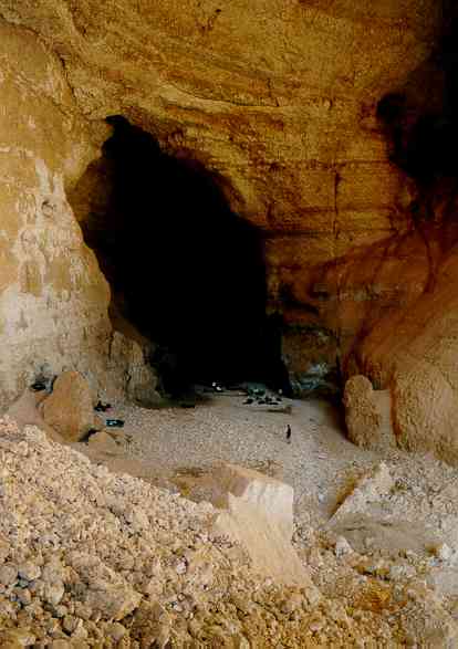
Inside the Kahf Al Tahry cave in Oman, bright light
due to the morning sun
Impressive
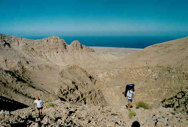
2 days ago I walked along a
deep canyon in the mountains in Oman and spent the night in a pristine huge
cave. Last night I slept on the plane in a business class seat and tonight I
did some step-aerobics in a posh fitness club. The contrast can’t be larger,
from a 1001 nights Aladdin’s cave in the mountains of Oman to the western
substitute of physical exercise inside.
The trek below is an
overnight trip, a 3-4 hour walk along a canyon, spending the night in a huge
cave, and 2.5 hours back. The trail along the canyon is reasonably marked and
there are no treacherous portions but you will need time finding the trail as
the local goats create numerous side trails.
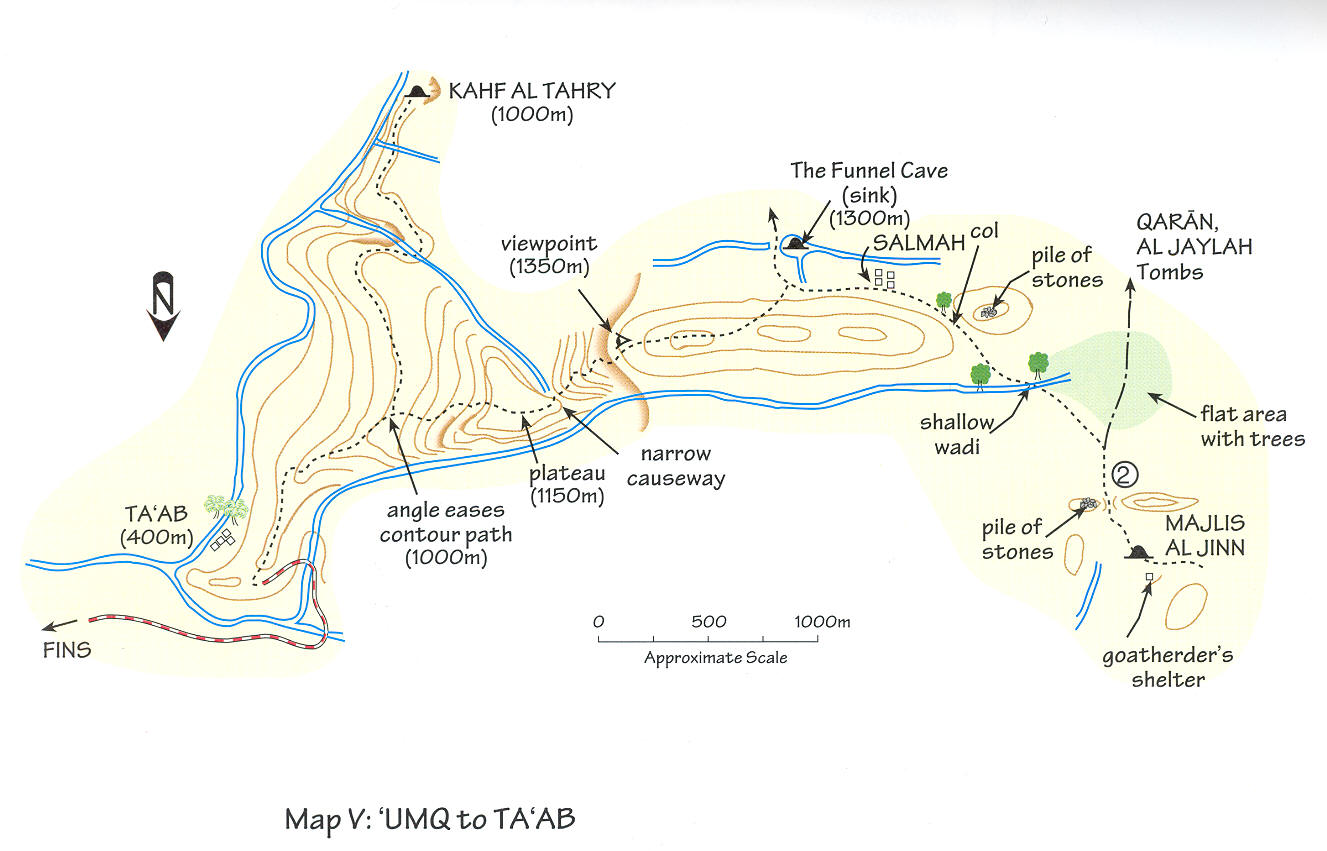
Map of the area showing
the trail to the Kahf Al Tahry cave. The second largest cave in the world, the
Majlis Al Jinn, is also indicated. From Dale and Hadwin. Adventure
Trekking in Oman.
Access
The trek starts near the
small coastal village of Fins, an over 2 hours drive South-East of Muscat. First
you drive for an hour on a tarmac road and this changes to a dirt road for at
least another hour. In February 2002 a tarmac road was being built that will be
extended to Sur.
In Fins you can see a dirt
road winding up into the mountains. Just past Fins you turn to the right, go
through a few houses, keeping right (the left road is a dead end to a garbage
dump) and hopefully you are on the right track to the mountain road which first
heads left of the winding visible part in the distance. If you don’t have a
four-wheel drive car you better leave the car at the base of the steep road and
walk the last 3-4 km. Once you pass a goat and donkey camp [1] to your left you are already in the
canyon and after another km the road widens and ends as the steep part going
down to a wadi is washed out. This is roughly 11 km from Fins and at GPS
location 0720100 2533200. Here you can turn the car easily. Do not drive down
this part of the road as it is rocky and steep. You may not manage to go back
up again.
Trek to the cave
Start walking, in early
February the midday temperature was around 27 degrees Celsius. Go down to the
wadi and up again to the pass where you can see the palm trees of the hamlet of
Ta’ab and this has only a few houses. At the pass follow the trail winding
along the main ridge by carefully watching the rock cairns. Here the goats have
created numerous side trails and you may have to back track a few times to find
the proper trail.
The trail is first on the
right side and near the top of the ridge for a few hundred meters and then
veers of to the left for 300-400 m staying some 30-40 meters below the ridge. It
suddenly cuts up steeply back to the ridge and this is not easily visible but I
made a few more rock cairns to mark it. Here it is again on the right side for
300-400 m nearly on top of the ridge. So far the ridge was reasonably level but
now there is a split in the trail, one cutting up to the right and not so well
marked and one to the left staying level and very well marked with cairns. Follow
the left trail [1] and
after 200-300 meter you see steep rock walls and can now pass the wadi. Here
the GPS location is 0719750 2531808.
Once you made it this far
the going is relatively easy. The path now cuts up on the steep ridge [1],
Canyon, looking towards the sea. Path follows
middle-left ridge. 4WD trail visible in the far distance below the far ridge.
Don’t take the one on the
right as I did, but simply aim straight ahead for the cairn clearly visibly
higher up the ridge. Roughly 50 meter higher you are now on a plateau. Follow
the trail across the plateau and after a kilometer you are on the side of the
canyon with panoramic views [1]. From now on the path will roughly follow the
contour lines of the canyon. Here there is a big side canyon [1][2] you will need to cross.
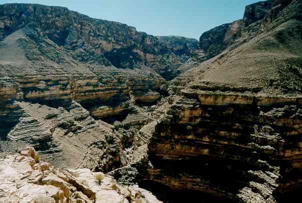
Split of canyon, roughy 300-400 m deep, view to the
SW. Path visible top right. Cave is 1 km SW.
Just follow the trail for
roughly 500-700 meters and you will be able to cross it at a spot with big
boulders [1] where I
saw wild donkeys. Now we are roughly 1 km from the cave. Keep going on the path
along the steep canyon [1] and you will see the cave in the second side
valley [1] at GPS
location 0719200 2530000.
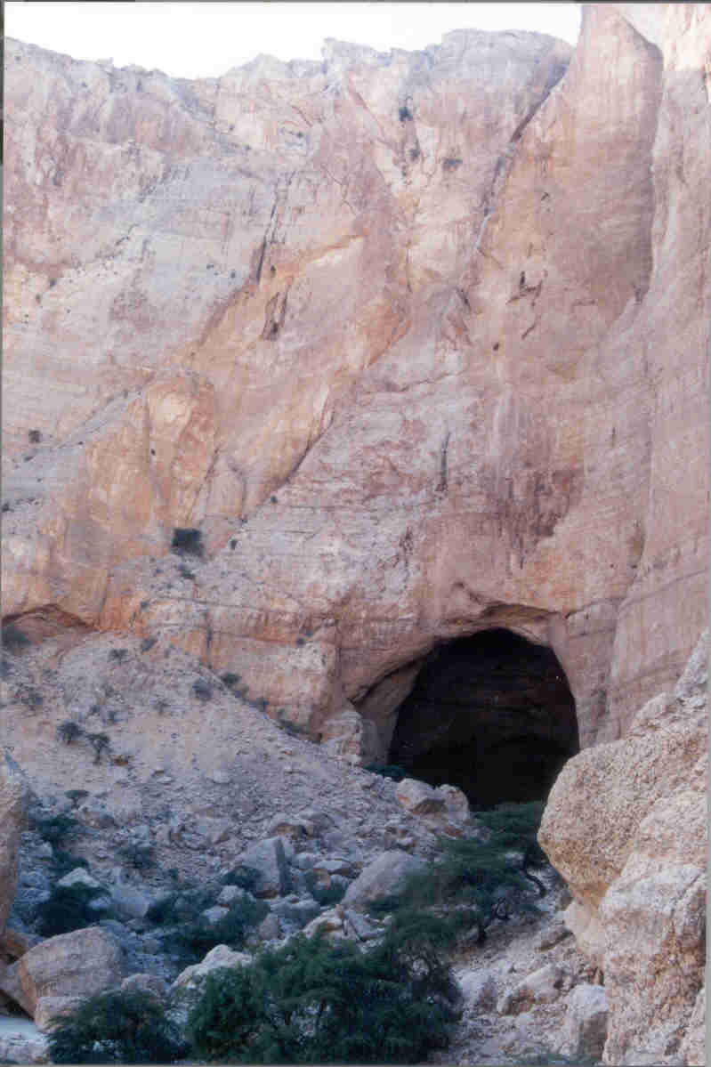
The cave is clearly visible
from a distance of 500 meters as a big hole 20-30m across in a roughly 200
meter high rock face [1][2][3] and after crossing several boulders you will
be able to enter.
![[1]](oman0202.jpg)
![[1]](oman0205.jpg)
![[1]](oman0204.jpg)
![[1]](oman0206.jpg)
![[1]](oman0208.jpg)
![[1]](oman0209.jpg)
![[1]](oman0210.jpg)
![[1]](oman0211.jpg)
![[2]](oman0212.jpg)
![[3]](oman0213.jpg)
View at the Kahf Al
Tahry cave entrance. Wall is roughly 200 meters high and cave entrance about 30
m high and 20 m wide.
Overnight in the cave
Inside the cave is roughly
20 meters wide, 30-40 meters high and the flat part is about 200 meters long
with nice gravel and sandy part for camping [1]. There is no water except for a few puddles
with stagnant water further inside. Swimming and drinking the water is not
recommended.
We made a fire inside the
cave but dead wood is already sparse and you better not use the remaining bits
and pieces. Dead wood is vital for insects to live and breed.
The sleeping is very
comfortable on the level gravel and sand bars and the temperature at night was
around 20-21 degrees Celsius. There were no mosquitoes or other biting insects
at night.
Inside the cave
The cave is part of a
tunnel system of roughly 16 km and there is a passable route of about 2 km
starting from the other side, see The Funnel Cave sink on the map. We walked
inside the cave starting at the end (down stream) and knew we would be stopped
halfway. We crossed numerous big boulders and the walking is not easy but never
treacherous involving climbing over or crawling underneath 2-3 meter high
boulders. One fixed iron rope ladder helped us to cross a 4 m high wall.
After roughly 45 minutes
and 1 km we came to a vertical wall with a hanging static rope. Here we
stopped. Normally you should come from the other side and its seems that you
need 200 m static rope to make it through the in total 2 km tunnel system
starting at the ‘The Funnel cave". Walking back to the entrance took us 25
minutes.
Walking back to the road
We started walking around
11 AM and there was the temperature was a comfortable (for Oman) 27 degrees
Celsius. Most pictures below were taken in the morning with the midday sun
shining in the canyon.
It took us an easy 2.5
hours to walk back to the road, now with a much lighter packsack as most of the
food and water (some 3 liters per person) were gone. On the last ridge down,
roughly the last 500 m to the road, the goat trails fooled us again and we had
to climb back to the last ridge.
On the way back to Oman,
roughly 10-15 minutes from Fins, we stopped at a public beach. Two donkeys
approached us but were very shy in taking the remaining food offered. The male
donkey took most of it pushing away the female but she tried to hit him with
her back feet, typical donkey style, and a finally got a few bits and pieces.
Summary
This was a fantastic trek. A
combination of rugged mountains, a very comfortable, overnight address,
pristine wilderness and a cave trip.
Pictures
of the cave trip
|
TITLE (to click on) |
File name |
Date |
|
Oman0201.jpg |
Feb 2002 |
|
|
Oman0202.jpg |
Feb 2002 |
|
|
Oman0203.jpg |
Feb 2002 |
|
|
Oman0204.jpg |
Feb 2002 |
|
|
Oman0205.jpg |
Feb 2002 |
|
|
Oman0206.jpg |
Feb 2002 |
|
|
Oman0207.jpg |
Feb 2002 |
|
|
Major side canyon, person on the left, visible trail follows contour
lines, view to the NW |
Oman0208.jpg |
Feb 2002 |
|
Oman0209.jpg |
Feb 2002 |
|
|
Oman0210.jpg |
Feb 2002 |
|
|
Cave entrance, note trees for scale. Rock face is 200 m. Photograph by
Dave Brindle. |
oman_dave01.jpg |
Feb 2002 |
|
Oman0211.jpg |
Feb 2002 |
|
|
Oman0212.jpg |
Feb 2002 |
|
|
Oman0213.jpg |
Feb 2002 |
|
|
Cave inside, light by the morning sun. Cave passable for another km. |
Oman0214.jpg |
Feb 2002 |
Pictures near Muscat
|
TITLE (to click on) |
File name |
Date |
|
oman_1.jpg |
Feb 2002 |
|
|
om02pt01.jpg |
Feb 2002 |
|
|
om02pt03.jpg |
Feb 2002 |
|
|
City of Rumi near Muscat. Note contrast with
barren mountains. Photograph by Paul Taylor. |
om02pt02.jpg |
Feb 2002 |