Home page: www.treks.org
Table of Contents "On the road to Kabul
and other short stories of treks"
Oman
Wadi Bani Awf: Little and
Big Snake River Gorges near Bilad Sayt, August 2003/Nov 2003
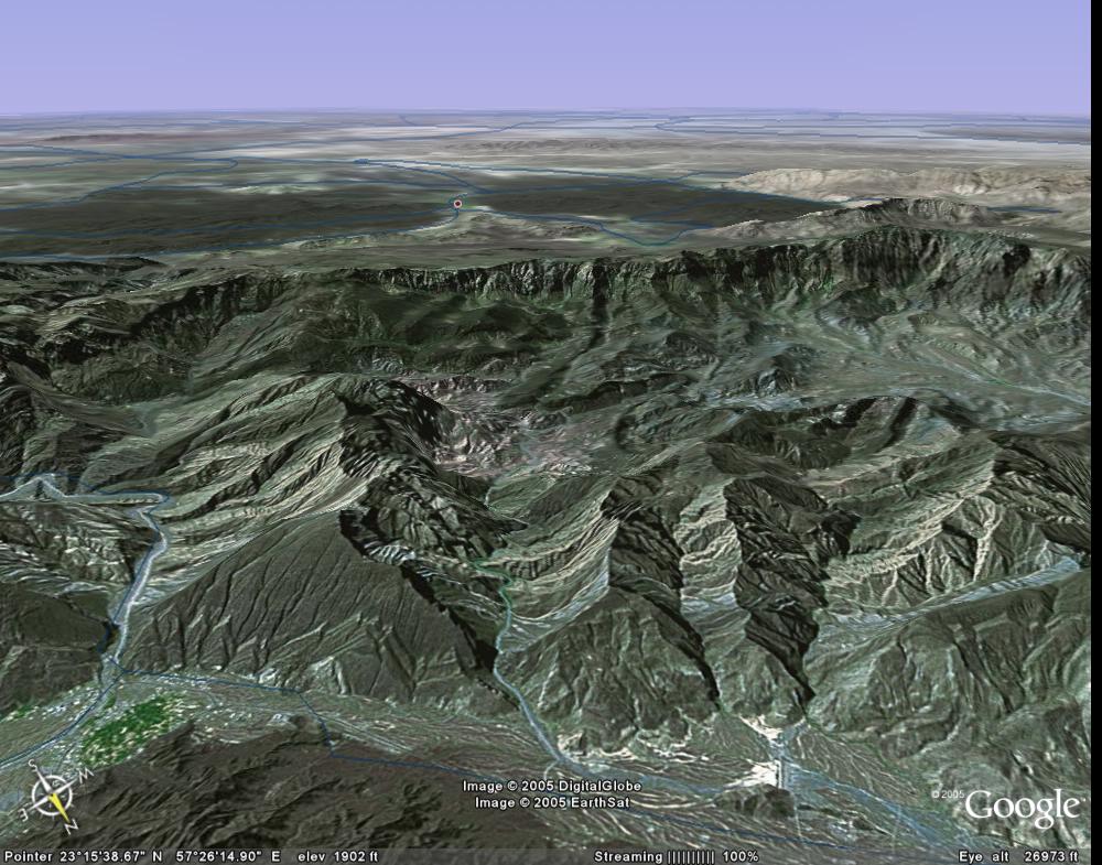
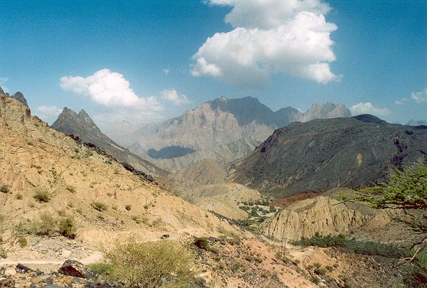
Wadi Bani Awf (centre), view from the
access road between Nakhal and Rustaq towards the main mountain range. After Google Earth.
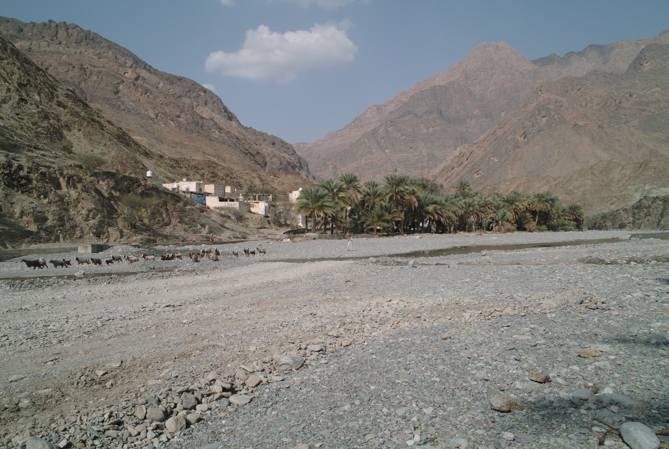
First village, with goats. View North-East.
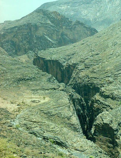
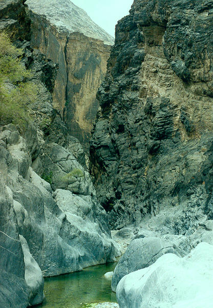
Snake
River Gorge, view down stream, detail.
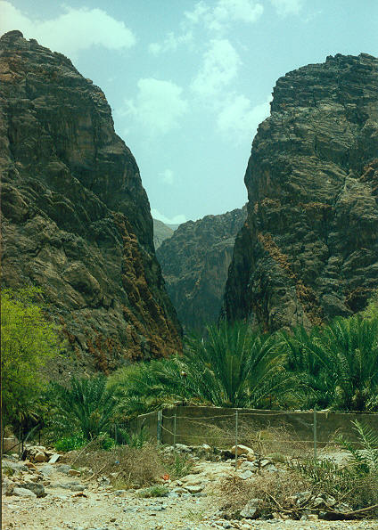
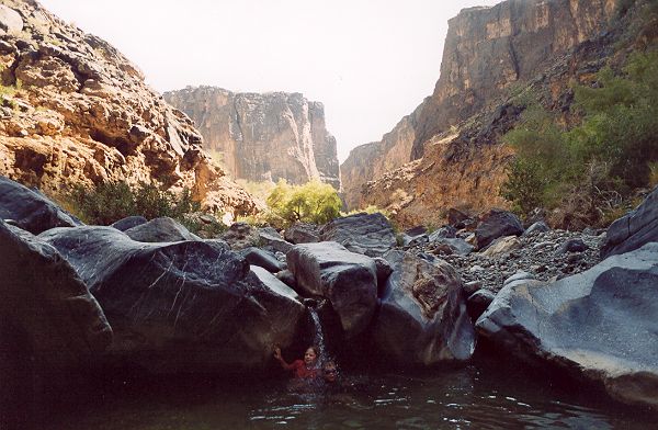
Snake
River Gorge, exit at Zammah.
The narrow
part in the Little Snake River Gorge has a 100 meter long pool in a narrow
canyon.Ā Swimming across,Ā a small grey snake is lying on a rock ledge.
On returning, picking up the towel covering a bag, anotherĀ snake is hiding underneath, a cool place.
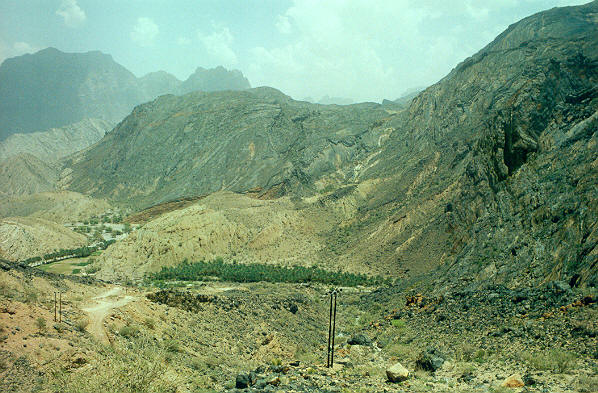
Wadi Bani Awf
The
entrance of the Wadi Bani Awf is around 43 km past the oasis of Nakhal, a 1.5 h
drive NW from Muscat on a 2-lane tarmac road.
Around
Nakhal the road runsĀ through dark hills
of barren brown rocks called ophiolites, oceanic rocks that were thrusted on to
the carbonate rocks by the closure of an ocean around 80-70 million years ago.
This is a rocky desolate landscape,Ā the
magnesium and chrome-rich rocks preventing most plants to grow except in river
beds.
Entering Wadi Bani Awf
The wadi is
sign posted on the road 43 km past Nakhal, a few km past Al Awabi. The gravel road is well-maintained
but can be rough in places, especially after rain showers, so you need a reliable
4WD.
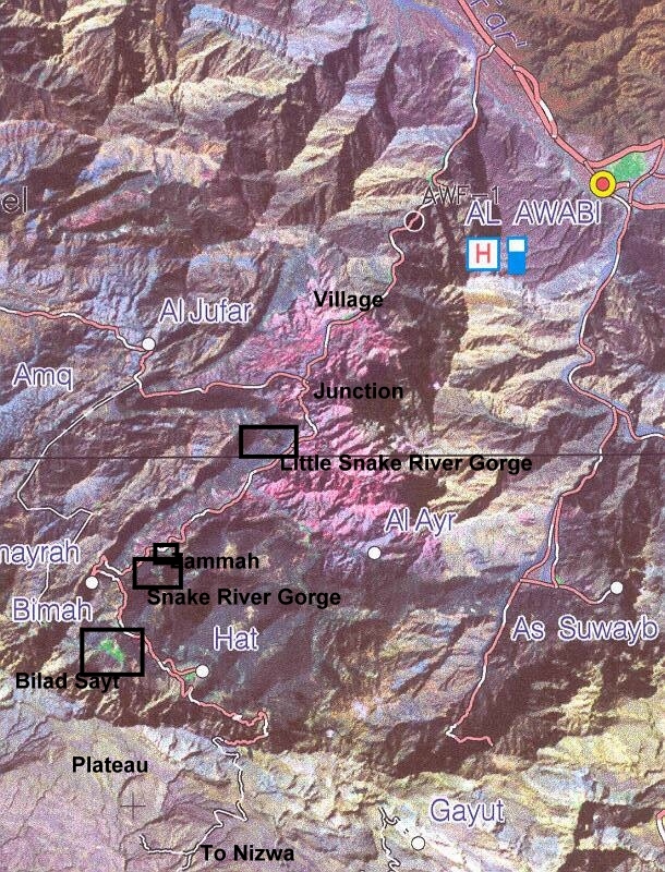
Satelite Image of the Wadi Bani Awf.
The first
10 km runs through a narrow winding canyon of limestone, a very scenic area.
The valley widens at a small village and now rocks consist of soft shales and there
is fallaj [1] in the main valley.
![[1]](om03n20.jpg)
Villages in
this region keep bees and the dark-brown desert honey is said to be of very
high quality.
After
another 4 km there is a junction with signs and here we take a left turn
towards Zammah (10 km) and Bilad Sayt (15 km).
A barely
noticeable cemetery with simple slabs of grey shale rocks indicating the
gravesĀ isĀ past the Little Snake Gorge on the North side of the road, after
about 6-7 km.
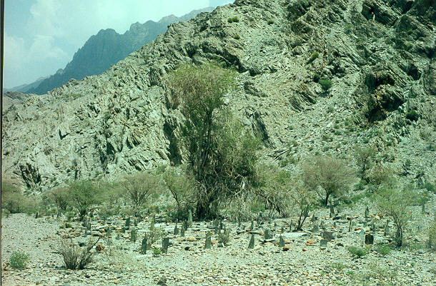
Cemetery
Little Snake Gorge
This canyon
is on the south side of the road, about 3-4 km past the junction andĀ about 6-7 km before Zammah.Ā The canyon doesn't have an official name but
we named it after the well-known Snake Gorge between Zammah and Bilad Sayt. The
narrow canyon entrance on the South side is well-visible, only 100 m from the
road.
Little
Snake River Gorge, entrance.
A mostly dry stream except
for a few murky pools South of the road makes a sharp turn and flows down into
the canyon. At the entrance there are a few clean, shallow water pools. This is
also a nice picnic area with a few trees for a welcome shade.
The first
500 m the canyon is narrow and depending on the water level you may have to
take off the hiking boots. Teva slippers are more convenient but do not protect
your feet walking in the very rocky terrain but this is personal preference.
The next km the valley is broad and you should try to follow the trail among
big boulders but this is poorly visible. In one spot you will have to scramble
across a few big boulders but this is not difficult and fun. You will pass a
few shallow pools
Small pool with
water fall, children for scale.
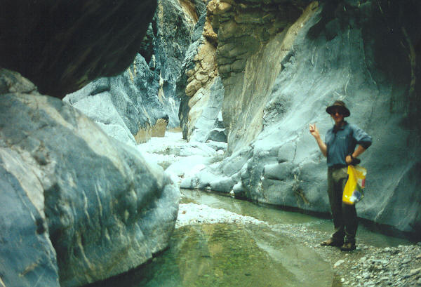
before reaching the second narrow canyon, our target, which is only 5-10Ā m wide. The main 100 m pool starts well inside this canyon past shallow pools.o:p>
Narrow canyon with small pools.
and you will need to wim if you want to continue. [1]
![[1]](om03n22.jpg)
Main 100 m pool in the Little Snake River Gorge.o:p>
The pool is deep, more than
5 m, and there are ledges to hold on to if you get cramps. Not unlikely as the
25 ║C water and the warm over 33 ║C outside temperature cools downs your legs
rapidly and a few strong leg strokes could do it.
Swimming
across,Ā a small grey snake is lying on
a small rock ledge. There must be more, in the water ģ., where we are, as in
the vertical canyon walls this isĀ the
only access. A creepy feeling, as nobody knows if these snakes are poisonous.
At the
other side of the pool the valley is broad again. I did a reconnaissance too
see how far you could go. After a few hundred meters there is another narrow
canyon which can be easily crossed and there is only a single obstructing water
pool. Past this canyon, the area is fairly flat and there seems to be a little
used 4WD trail, likely going back to the junction near the village. A full
crossing seems possible when usingĀ
waterproof bags to swim across and a pick up by car at the other end.
The sun is
burning hot on the bare skin and we do not stay long and swim back. When picking
up a Ātowel covering a bag, a grey snake
is hiding underneath. A nice, soft cool place in the hot, rocky terrain, but it
gave a fright to the female owner of the bag.
Would be
good to know if these grey snakes are poisonous but it was definitely not a
cobra, see overview ōSnakes
of Omanö. Still, it could have been a viper but this is unlikely as
poisonous snakes tend to be extremely cautious being hunted down by the locals.
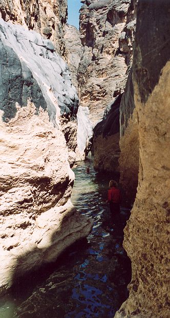
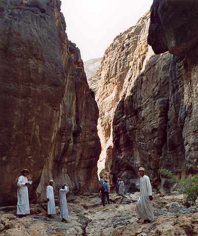
Snake River Gorge
At the
village of Zammah is the start of a 5 km winding, steep mountain road that runs
to Bilad Sayt.
Winding mountain road
from Bilad Sayt back to Zammah (far distance).
View at the oasis of
Zammah (trees, far distance) with exit Snake River Gorge (right).
You have a panoramic view
of the Snake River Gorge.
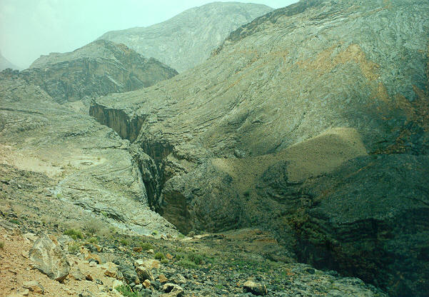
Snake River Gorge,
overview.
TheĀ narrow canyon is around 2 km longĀ and runs E- W, see
detail. It is ōtheö favorite canyoning area in Oman with Wadi Bani Khalib
in the Eastern Hagar a good second.
The only
canyon access is upstream, where the East extension intersects the road.Ā The canyon trip takes about three hours and
is a mix of swimming, jumping down a few meters from rock ledges into pools and
walking in a rough gorge. You cannot go up anywhere to cut it short and once
you jump down into the first pool you cannotĀ
turn back either. The exit is at the village of Zammah [1] [2] [3].Ā Only experienced groups should do this trip.
In the late nineties, a sudden heavy rain caused a flash flood, a wall of water
rushing through the canyon and killing a party of several peopleĀ (Ref.Ā
To be found) as there is nowhere to go up for safety. In narrow canyons
in Oman the water level is typically raised by 2 to 5 m. In the Little Snake
Gorge I saw mud traces from high water 2 m above the valley floor.
![[1]](om03n30.jpg)
![[2]](om03n27.jpg)
Bilad Sayt
The village
of Bilad Sayt is a large oasis at the foot of the 1000 m high mountain cliff of
the Jebel Shams. The road continues up along the cliff, by passing the
village,Ā and onto the plateau of the
mountain range but is narrow and steep.
It in the
far distance,Ā it is visible creeping up
the giant mountain wall of the Jebel Shams Ridge with an elevation of of the
plateaus around 2500 m and two highest mountains of 3000 m. The road leads
across, to Nizwa. This is a favorite drive for expats, a round trip from Muscat
takes around 10 hours. There are also old trails from the village up onto the
plateau, a long 1000 m ascent.
From the
main road, past the side road to Bilad Sayt close to Hat, a narrow canyon leads
to the village.
Gorge from the
main road to Billad Sayt. With local Omanis.
Initially you will have to
find your wayĀ across a 10 m high cliff
but there is trail on the right and in the weekend young Omani men will help
you out as this seems to be a local meeting place.
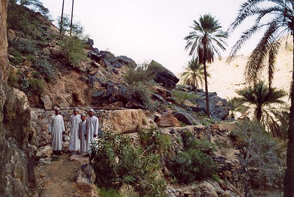
Trail up from the bottom
right, poorly visible. With local Omanis.
Halfway there is a choice
to go left or right. The left canyon comes out above the village,Ā into a green vegetable garden area,Ā and the right canyon at the entrance of the
village at the main village road branching of from the main road.
Young Omani
men hanging out at the canyonĀ guided us
to the village and offered us fresh dates.
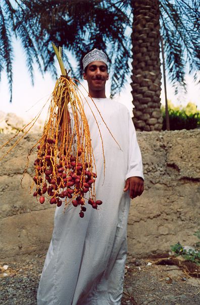
Young Omani
offering fresh dates.
The scenery is spectacular,
a large village with a few thousand people living in a giant green oasis
atĀ the foot of a 1 km high rock wall.
Epilogue
A trip to
Wadi Bani Awf is very scenic butĀ
reserve at least 8 hours for a round trip. Avoid this wadi during rainy
periods as some of the roads may be flooded. A reliable 4WD is highly
recommended.
The steep mountain
road past Zammah to Bilad Sayt and further across the mountains to Nizwa should
be avoided during rainy periods as the road becomes slippery.