Home page: www.treks.org
Table of Contents "On the road to Kabul
and other short stories of treks"
Oman
The Sayq Plateau: a wet
August and Princess Diana’s Point
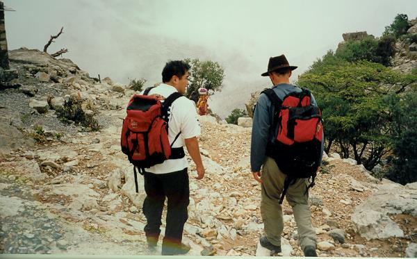
Donkeys onthe Sayq
Plateau, during low overcast down in the valleys
Following
the canyon down from Ru'us on the Sayq Plateau at 2700 m, it gets more and more
cloudy and the drizzle changes to a steady rain. The temperater drops from 25 to 19 o Celsius. We turn
back. Rain in Oman in August. In Muscat it is 40 o Celsius.
Oman, August 2003
In August
of 2003, Muscat is very humid and at
times it rains which is exceptional. This year the monsoon has come more North
but normally it only hit the South of Oman at Salalah. Temperatures are also a
lot cooler, around 38 to 40 o Celsius instead of 40-45 o
Celsius. This is still too warm to swim in the Intercontintal Hotel pool as it
heats up even more by the sun and the pool water is not cooled Iike in the
nearby Hyatt.
Weekend escape
To escape
the summer heat we decide to do a mountain trek on the Sayq Plateau, a large
over 2000 m high limestone plateau on the Western Hajar Mountains, part of the
coastal mountain ranges. Here the
temperature is much cooler, 15-20 o Celsius less than on the
coast.
Access to the Sayq Plateau
The access
road to the plateau is at Wadi Muhaydin near Nizwa, about 120 km NW of Muscat
along a mostly four lane highway.
The main
access road up to the plateau starts
near Birkat in Wadi al Muhaydin. Turn
obligue right after about 4 km into the wadi
and drive up the graded road.
If you miss
the turn-off like us as there is no sign,
you could explore the main wadi by just following the main wadi road.
Wadi Muhaydin, main wadi
road going North.
for another
15 or 20 minutes till a large village.
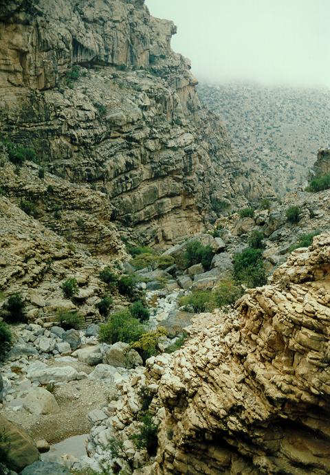
Past the
village the canyon now narrows to 500-800 m high, near vertical limestone
faces, a very scenic area.
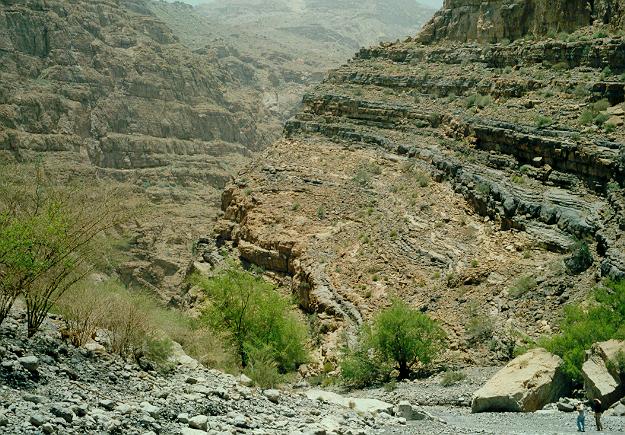
Wadi Muhaydin, narrow
part near the end of the rough 4WD trail.
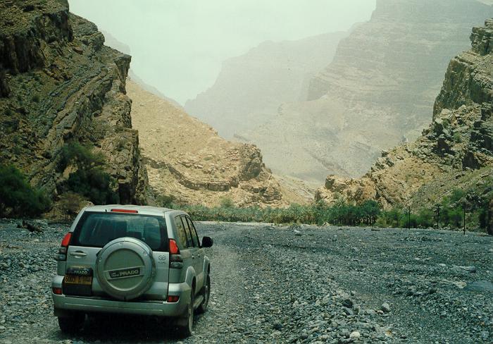
This
track is now only accessible by a good
4WD vehicle. You will find a small camp
site between the trees some 500 meters past the village.
A very
rough track takes you another km upstream so we left our 4WD behind. At the end
of the track, on the right side, there
is an overhanging rock face with shelter against the sun, a favorite spot for
Sunday pick nick by the Omanis.
Unfortunately, there are no pools for swimming [1]
but the area is great for camping at night which I did in February 2003.
![[1]](om03je19.jpg)
Sayq Plateau Access Road
The access
to the Sayq Plateau is controlled by a
military checkpoint at the start of the mountain road as the plateau is considered a military strategic
area. You need a permit to get in, e.g.
by staying in the only hotel of the plateau, the Jebel Al Akhdhar Hotel (Tel. 429009 (?) / 24590424 (Muscat).
Camping will not get you a pass and is probably prohibited. The hotel will pass
on photocopies of your passport to the authorities and send you a form to prove
you have a reservation and permission to enter.
The road
was being asphalted to a tarmac road
when we visited in 2003 and it winds up to the plateau for 30 minutes to cover
the one km vertical altitude difference. We are driving through mist formed by
the overcast clouds during the humid August and follow the lights of slow driving cars in front of us to avoid
driving off the one-lane winding mountain road. At 2 km altitude we rise above the clouds.
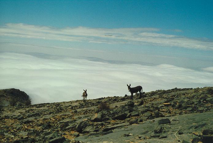
We pass the
village of Manakir [1], the end of the 8 hour Wadi
Halfayn trek when walking up from the four lane highway (the Muscat-Nizwa
highway). Here we stop to enjoy the view, the mountains surrounded by a blanket
of low hanging clouds, and being watched by two curious donkeys standing on the
barren grey limestone rocks [1].
![[1]](om03je20.jpg)
We follow
the road for another 30 minutes and in the distance have a view at the main
town of the plateau in the far distance, Sayq. On the outskirts, before entering the town, there is the hotel, a large two-story
buiding with around 50 rooms. You can't miss it as it is the first prominent
building.
The
temperature at noon is only 25o Celsius but the sun is very bright.
In Muscat it is now 40o Celsius.
Trek
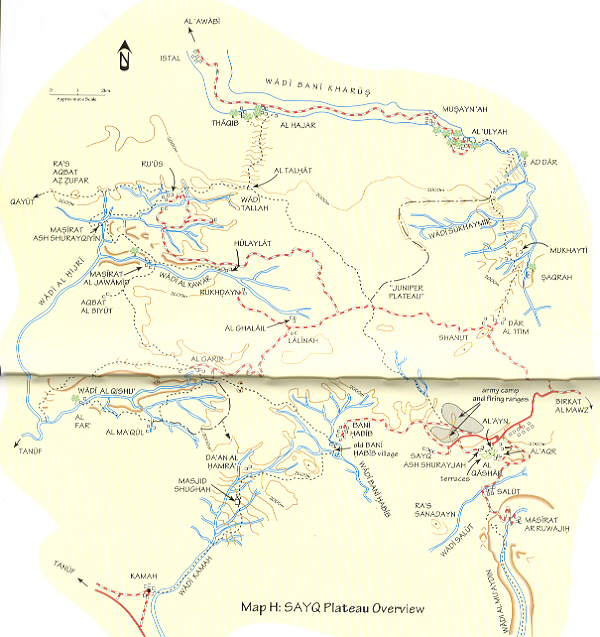
Sayq
Plateau, only access road from Birkat right middle. Wadi Muhaydin bottom right.
Hulaylat and Ru’us top left.
After
checking into the hotel and having lunch,
we drive further up to the highest area at 2500 m. We pass the so-called
juniper woods [1] [1],
which has widely spaced juniper trees, only one every 50 m, on mostly barren
limestone rocks. Junipers must have covered this area a long time ago but are
now sparse. This area is popular for star watching given the high altitude,
there is a very clear sky at night with bright stars.
![[1]](om03je23.jpg)
![[1]](om03je22.jpg)
At the
village of Hulaylat [1] there is a trail down into the
canyon and is marked as level 1, should be easy. It is the start of the 6-8
hour trek to Ru-us through the two villages of Masirat. Ru’us is the end of the
road.
![[1]](om03je21.jpg)
Going down into the
valley below Hulaylat.
One of the
trekking members doesn't like the steep trail going down some 400 m into the
canyon as he has fear of heights. Women coming up with big water jars tapped
100 m down at the lower water reservoir, a daily routine, cannot convince him,
it is an easy trail, just level 1. Some parts all the way to Ru-us are more
difficult, between the Masirat villages it is level 2 and 3, and would require
'scrambling' across steep ledges.
We abandon
the trek and drive to the village of Ru-us, the highest point of the plateau at
2700 m to try the other end of the trek. Villagers greet us and offer us coffee
and tea but we decline as it is already 3 PM and we still want to do a bit of
trekking. The sun has disappeared due by a thick overcast and mist, and the temperature is going down. The
valleys have low clouds, an indication of high humidity and the overcast
thickens.
Going down into the
valley below Ru'us.
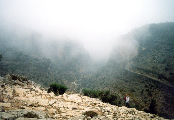
We go down into the valley [1] following one of the numerous goat trails and after almost a km get stuck on a cliff 10 m above the valley floor.
Bottom of the valley
below Ru’us.
There is
suppose to be a trail down but the barren rocks and numerous goat trails
obscure the main trail. We finally find it close to the main valley. Some parts are collapsed but it is fine,
being a bit steep or narrow in places.
The trail
stays at the bottom of the valley for only a few hundred meters and continues
on the right side going up slowly along steep mountain cliffs where it is
clearly visible as there is only one route.
Mist is
forming and there is a light rain but we carry on. After a few km we are high
up and have views at a deserted hamlet below. In the far distance we can see
the main valley turning left, at a 1-2 hour distance, leading to the village
of Hulaylat where we tried to go down
earlier
The rain is
now steady coming down and I pull out an umbrella [1].
We decide to go back but still get very wet [1]
before getting back to the car.
![[1]](om03je25.jpg)
![[1]](om03je26.jpg)
Driving
back to the hotel, rain clouds cover the mountains completely and the
visibility is only 50 m. We drive slowly following the lights of a car in front
which drives even more slowly waiving us we should pass, but we decline as he is a safe guide to stay
on the road.
Next Day, Dianna's Point
It was cool
last night, possibly down to 10 o Celsius and I used blankets.
Near the
main town of Sayq there is a splendid panoramic view point of the main canyons
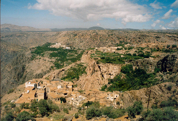
with green terraces [1] [1]
[1], called Diana's Point by the information sheet
of the hotel.
![[1]](om03je08.jpg)
![[1]](om03je29.jpg)
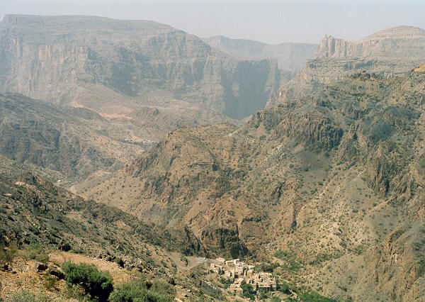
Panoramic view from
Princess Diana’s Point, view left.
Panoramic view from
Princess Diana’s Point, view right.
Diana's
Point was named after Princess Diana during a visit, probably in 1988. She is
said to have stayed here enjoying the view for many hours just sitting down and
staring in the distance, presumably contemplating how to continue her life with
‘flappy ears’.
You can go
down into the main canyon by car along a steep (20 degrees) dirt road but the
road ends soon. Somewhere there is also a trail down into Wadi Muhaydin but do
not expect any signs.
Summary
The Sayq
Plateau is a cool area in the Western Hajar Mountains to escape the summer
heat. With more rainfall and cooler temperatures, people seemed to have lived
here for at least 4000 year.
Mountain
trekking in Oman in the mist and rain, on the over 2000 m Sayq plateau with its
large canyons it may happen.
Note that
there are no sign post on the plateau in 2003,
possibly because it is a restricted terrain and navigation requires a
good map.