Picture
Book: Arctic hares on Eastern Axel Heiberg Island, Northern Canada,
July 1982.
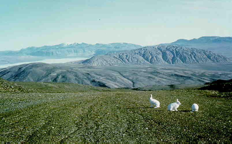
Arctic hares on Eastern Axel Heiberg
Island, in front of a salt dome (500 meter high mountain, 5 by 7 km)
near Mokka Fiord (ice covered bay). Mountain Range in the far
distance at 40-50 km. Early July 1982.
For location see [1].
Three
Arctic Hares on the barren land. One is eating grass and the other
two are on guard. They are ready to take off if we would come too
close, usually going uphill. No chance catching them, even wolves
would have a hard time. We saw thousands of them in this area last
week, sometimes a whole mountain side was covered with white hare
dots. We also saw young rabbits hiding in grassy areas, must be a
feast for wolves and foxes.
This was a good Arctic hare year, never saw so many.
We shot two of them a few weeks ago for meat but they were too gamy
and tough, lost their winter fat completely.
Ice on the fiord
in the distance, still too early in the season, it is early July,
1982. The ice will break up in another 3-4 weeks. In some years it
never does. In the far distance the Buchanan Lake pass, the land pass
all the animals have to take traveling from North to South on Axel
Heiberg Island when the solid ice on the fiords has broken up in
July.
The topic of the picture is not the hares but the 6 km
wide and 500 m high mountain with deep gullies at some 10 km
distance. This is a salt dome, or more precise, anhydrite with a
thick undergound core of rock salt (NaCl). The cold and dry High
Arctic climate preserves the salt rocks reasonable well. In 1988 I
will be on top of this mountain several times and leave footprint in
the clay. These will be visible for at least 10 years.
There is weathering, the hygroscopic anhydrite turns
into gypsum and this is carried along by the melt water streams
during the short summer with average temperature of 4 Celsius,
usually only one or two months. It leaves a thick cap of clay and
carbonate dissolved in small amounts in the anhydrite, covering the
salt minerals like a protective clay hood. The salt dome took
millions of years to move its way through some 10 km of vertical
sedimentary rocks, mostly sandstones and shales. It probably still
moves up by around 1 or 2 cm a year otherwise the weathering would
have reduced the large mountain into a much smaller hill or even a
depression.
The lines going down hill are frost heaves, solid
particles heaved up and down by the frost causing the rubble to very
slowly move down the hill, a solid "river" of rocks and
dirt.
My first time in the Arctic, June-August, 1982, a
full two months. Was not easy, mainly due to the cold temperature, on
average 4 Celsius. The 24 hours of bright sun light was very tiring
on the eyes, at mid day the sun is at only 30 degrees above the
horizon but at mid night still 20 degrees,
A memorable picture.
(Back to picture
book page)