Table
of Contents "On the road to Kabul and other short stories of treks"
2. Escape from the Cares Gorge

Jou Santu, a large sink hole 2 km across in the karst rocks. Photo to the West taken at the main pass of 2000 m (leads to Cain) on July 8th, 2004. Temperature 1 degree Celsius, storm conditions with intermittent hail and rain.
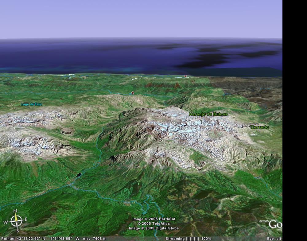
Cares Gorge, view from the South. After Google Earth.
How to escape from the Cares Gorge of the Picos de Europe on foot and avoiding a 3 hour taxi ride? Alternatives are the 9 hours high route along a path 1500 m up, or a 1200 m scramble along an unmarked lower route of only 6 hours.
The path got preference given the poor weather. At reaching the 2000 m pass after a 5.5 hours steady climb, we were welcomed by a fierce Western wind gushing through the peaks and as a bonus intermittent hail and rain. Temperature was 1 degree Celsius, visibility 10 m after wiping the constantly fogged up glasses. It is now 2.30 PM, we estimated at least another four hours to go to Refugio Vegarredonda through the rocky high country with plenty of snow fields to get soaking wet boots.
What route to take
The barman in Hotel La Rutta in Cain could not help us what route to take out of the Cares Gorge. The number one choice seemed the only well-marked trail1500 m up a reasonable path, 2 more hours through sink holes with no doubt a rocky trail going up and down and through snow fields, and finally 2 hours down along yet another rocky path to a refugio. The alternative was not appealing and only possible in good weather, a 1200 m scramble up along scree and solid rock in the Canal de Trea with only few markers, if any, but very close to the refugio near Vega de Ario.
A week ago, on the first and easy day, we did already the third and easiest alternative, the low route from Lago Ercina across the 1427 m high pass, Collado Sierra Buena, through Oston, which is only 6-7 hours, but today was suppose to be ‘top day’ [map with routes].
![[map with routes]](picosescapemaproutes.jpg)
The weather was poor this morning, low clouds, already at 9 AM and temperature of only 8 Celsius. The barman suggested to take the difficult Canal de Trea scramble as the pass was lower and close to the refugio of Lago Enol, a day trippers favorite only two hours from Lago Ercina, 'You could be there for lunch', he said but admitted it could be very difficult and he never had done it himself, not even the high route along the path. Without any useful information we decided to take the safe marked but much longer trail.
A Frenchman was asking us about the Eastern mountaineering route from Cain at 500 m to Cabaña Veronica at 2350 m through the Canal de Dobresengros [1, far middle] [bottom-right on map]

View at the Canal de Dobresengros, far middle.
and walk down the espadrilles route to the top of the cable car at 1850 m at Fuente Dé. Yesterday, when selecting a route from Fuente Dé to Cain, we dismissed this as a tough, irresponsible scramble down scree and solid rock with poor or no marks and this was even going down, much faster than going up. Even the lower well-marked trail across the high country, across the 2000 m plateau passing the lake at Llagu Bajero, we did not take given the poor weather, and we used the 6.5 h lower route through Posada de Valdeon. Yesterday, at the highest pass of only 1800 m it was only 5 degrees Celsius with intermittent rain.
The Frenchman insisted and said his teenage kids where good walkers. I hope he understood the words ‘trés difficile’ and we suggested he should take the popular marked route to Refugio Diego Mella at 2030 m, 1400 m up from Cordinanes or Corona, and would discover that he needed another day to pass through Cabaña Veronica at 2350 m to the cable car at Fuente Dé.
Going up
We left Cain at 9 Am, a bit late, and the first 200 m up to the shepherds hamlet of Cain de Arriba seemed a present. We quickly lost the South trail up the steep cliff which was suggested by a local old man, by following a right side lower trail used by cows only and ended up at a scenic waterfall and pool after crawling under low bushes. After getting our boots wet, we also had to scramble another 30 m up to find, to our surprise, the Northern trail that turned out to be a gravel road leading to Cain de Arriba. A half hour lost and worse, much needed energy for today. We should have followed the village road in Cain and watch for the clear green tourists signs [1].
![[1]](04pi401s.jpg)
From Cain de Arriba, the path going up in the big green valley was clearly visible in the far distance

and here we would have the last green sign indicating the path to Refugio Vegarredonda, todays target. The Spanish use very few signs on the high altitude trails which are little used, some only 2-5 persons a day. In the far distance we could see the steep cliffs [1] and somehow the path would lead us up. The only two fuentes (springs) of the day, at 900 and 1400 m, are in this valley and here we would have to stock up on water.
Just below 900 m we saw a waterfall and above the first spring the path becomes very steep and is cut out in solid rock of a 100-200 m high cliff with breath-taking near vertical views down [1]. Unlikely cows ever make it up here and after this cliff we only saw goat shit.
At the shepherds huts of Mesones [1][2] at 1400 m, the steep shortcut to the pass 600 m straight up did not seem appealing given the heavy scree and lack of markers so we followed the normal path up to the left to Hoyo Verte [1], the first of the large and very impressive sink holes a km across and covered in dark green grass. Sink holes are karst features, collapsed limestone rocks by dissolution of water and often with deep cave systems, some start at the surface and you do have to watch out for holes if you move off the trails.
![[1]](04pi404s.jpg)
![[2]](04pi404ds.jpg)

From Hoyo Verter, across mostly solid rocks [1], numerous cairns took us to the pass of 2015 m and in the mean time it started to rain as we walked slowly up into the clouds. Here we were welcomed by a chamois ('gems' or ‘Rupicapra rupicapra’), observing our ascend from a cliff.

5.5 hours to get here, temperature 1 degree Celsius. Little time for a break despite feeling tired and not in the mood [1] as the ceiling was coming down as it always does in the afternoon and a storm was rushing through the pass [1] (left). The second sink hole, Jou Santu, some 2 km across was again breathtaking [1].
![[1]](04pi407s.jpg)
![[1] (left)](04pi408s.jpg)
Luckily we found a big rock to shelter for the fierce wind. The boots and clothes were soaking wet, partly from sweating, but we could only afford a 15 minute break to warm up and changing into dry cloths. We also took a small lunch but eating made us cold again.
The path was reasonable until now but just before the highest pass of 2100 m to the third sink hole, it disappeared in a small but steep snow field in front of a 10 m high cliff. Unclear what to do, 50 m down following the faint foot steps in the snow field (and get again wet and cold feet) or up the steep (fourth grade) rock face. We went up.
At the 2100 m pass a strong wind loaded with hail and rain hits us full but the cairns of the trail seemed clearly visible. After several snow fields in the third sink hole and getting very wet boots by plowing through the snow, we got worried if we were still on the right trail down as there is also a long, side trail going South into higher country and this would certainly not lead us to any shelter except an abandonded refugio. We hoped we spotted this in the storm on the 2100 m pass behind us.
At the end of the small fourth and smallest sink hole, the trail suddenly widened to the size of an ATV track and we heard cow bells in the mist. The path was so well-built that it must be the espadrilles (tourist) path [1][2] for Spanish day-trippers and picnickers from the refugio we were going to. Within minutes we were below the clouds at 1900 m
![[1]](04pi412s.jpg)

being watched by several cows [1] and looking down to Lago Enol in the far distance in bright sunshine. Now we could see the route clearly between the peaks and sink holes and took a second short break, necessary to respond to a trekker calling for mercy as he did want want to continue and prefered a final escape using "the ritual pig slaughter method of the Dajaks of Borneo to welcome guest" [1][2].
![[1]](04pi416s.jpg)
![[1]](04pi410s.jpg)
![[2]](04pi411s.jpg)
Near the last sink hole we saw a large herd of chamois (‘gems’) quickly moving up a ridge [1] . It would be another 2 hours down to the refugio, along a foot and back breaking rocky path 500 m down [1][2][3] and we were getting tired [1].
![[1]](04pi414ds.jpg)
![[2]](04pi415s.jpg)
![[3]](04pi418s.jpg)
![[1]](04pi417s.jpg)
At 6.30 PM we finally arrived at the recently renovated refugio Vegarredonda [1][2] at 1410 m. We were welcomed by two big dogs, 3 horses and the wardens. There were only two other trekkers sofar.
![[1]](04pi419s.jpg)

Refugio Vegarredonda the day after.
The refugio is run by a couple in their mid thirties and their teenage son. It has plenty of food and sleeping places. At seven the drizzle started again and we decided to stay as the Refugio at Lago Enol at 1100 m would be another 2 hours down. Tomorrow we would try to walk down all the way to the highway, to Cagnes de Onis, enjoying an easy 7 hour walk down through forests and cow meadows [1][2][3]
.![[1]](04pi421s.jpg)
![[3]](04pi423s.jpg)

Some of us had to walk on character and not physical shape as they did have have much to rely on, and just made it [1]. Walking on character seem the best method in the Picos as physical shape tends to wear down quickly by the rocky paths, wet snow fields, high elevation differences, the always too heavy rucksack even when it is only 9 kg, and last but not least unpredictable weather.
At 2100 m it can be 1, 6 or 16 degrees Celsius, it can be foggy, haily/rainy or sunny, and you can be in, below or above the clouds.
Full light-weight Gore-Tex coat and pants against cold wind, rain, hail and snow, fleece gloves and hat, and sturdy water-repellent boots are highly recommended.

A trekker with very soar feet collapsed 4 km before the Picos finish near Intriago.
