A
RA
RAT
Visitor since September 2009:

Mount Ararat, view from the road between Iğdır and Dogubayazit.
June 1974, view at Mount Ararat, out of the bus, travelling from Erzurum in Eastern Turkey to Tabriz in Iran.
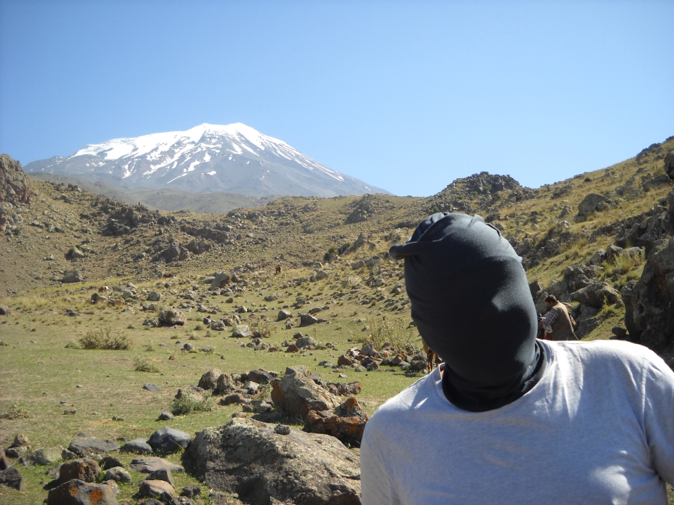
August 2009, 35 years later, standing at 3200 m in Camp 1, the glaciated top is visible and seems very near, only another 2000 m up.
Ararat is not a “Walk in the Coca Cola Park” like Kilimanjaro (5892 m), but a challenge.
Mount Ararat is a dormant stratavolcano and perhaps the most famous mountain in the Middle East.
It is mostly known from the Bible with the legend of the Ark of Noah. Muslim believe the ark landed on Mount Judi, a mountain near Mosul in modern Iraq. Ararat also features in numerous pre-Christian saga like Assyrian (see Wiki). The Turkish name is Ağrı Dağı and the Persian name Koh-i-Nuh, the Mountain of Noah.
There seems to be some truth to the legend of the Ark of Noach. Around 5000 BC, the giant Lake Agassiz glacial lake that formed at the front of the ice sheet still covering most of Canada, broke through the moraine dam and a massive amount of water and ice entered the Atlantic ocean, causing the sea level to rise 50 m and triggering a climate change. E.g. The saharah became much drier and changed from savannah to desert.
The Bosporus is a narrow gateway between the Black Sea and Mediterranean. The water level was so high that is flowed into the Black Sea for the next 50 or 100 years. A Niagara Falls size waterfall was formed and the Black Sea rose slowly, one meter per year.
Imagine the early farmers living on the coast. As the sea level rose slowly but steadily, they had to move higher up but after a few years it would threaten their houses and fields again. Settlements have been found along the coast that are now far below current sea level.

Mount Ararat, close up. Camp 2 at 4200 m is in the clouds, left side.

Map of Mount Ararat, elevation is 5137 m, not 5185.
Ararat is a stratovolcano, formed of basaltic (black) lava flows and pyroclastic ejecta, but it has no visible volcanic crater at the top which is entirely covered in ice.
You can see some lava or pyroclastic flows running down the mountain, those that are only a few thousand years old. The last eruption occurred during the last 10000 years. The map shows some vent holes, presumably from underground basaltic laval flows.
Wiki:
“It is not known when the last eruption of Ararat occurred; there are no historic or recent observations of large-scale activity recorded. The last eruption will have occurred somewhere in the last 10000 years. It seems that Ararat was active in the 3rd millennium BC; under the pyroclastic flows, artifacts from the early Bronze Age and remains of human bodies have been found.
However, it is known that Ararat was shaken by a large earthquake in July 1840, the effects of which were largest in the neighborhood of the Ahora Gorge (a northeast trending chasm that drops 1,825 metres (5,988 ft) from the top of the mountain). An unstable part of the northern slope collapsed and a chapel, a monastery, and a village were covered by rubble. According to some sources, Ararat erupted then as well, albeit under the ground water level.”
The flows reminded me of Etna [1] , but rocks are different, those I saw were basalt, a strong black rock with gas bubbles, like on Hawaii . Etna is more acidic and its recent flows resembles the cinders of a wood stove and every chunk may crumble when you step on it. Basalt is rock solid.
The soil is very fertile but we only see meadows for sheep. Winters are long in this area with the plateau at 1800 m and the area is covered in snow for at least six months of the year.
In the dry summer months, the volcanic clay dust sticks to your shoes and settles in your nostrils. A nose shower is recommended to clear the nostrils.
Ararat is not a “Walk in the Coca Cola Park” like Kilimanjaro but a challenge.
Until 4200 m the trail is relatively easy but above this, the going is steep, rocky and icy. Above this, high altitude sickness cause by lack off oxygen will strike hard.
Above 4800 m there is a large, mostly gently sloping snow field and you will need crampons for the icy and steeper parts. An ice axe is not required. On top it can be cold, we had -8 Celsius and gale force winds.
Ararat, like Kilimanjaro at 5800 m, is one of those Diamox mountains. Diamox is an eye sickness medicine, to remove the build up of water behind swollen eyes.
Mountaneers use it against High Altitude sickness, see Wiki. HACE, high altitude cerebral oedema, is very common. Here too much water enters you brain together with oxygen by a disturbed osmosis process (e.g. sweet water flows to salt water through a membrane) causing a split headache, nausea, funny stomach and lost of appetite.
More risky is HAPE, high altitude pulmonary oedema, where fluids enter your lungs and you may drown in the fluids within 16 hours.
Early signs of hgh altitude sickness are a headeache and loss of orientation. The latter can be dangerous.
As most people “do it” (climb the mountain) in only 3 or 4 days, you get very little acclimatisation. Twice a day, we took half a pill of Diamox in Camp 1 but a full one (500 mg) in Camp 2, at night and in the morning. At night, Diamox should be taken well before dinner as it increases your Number One frequency by a factor of 5, very inconvenient while sleeping during a cold night. Bed time is usually at 7 or 8 PM at this altitude.
Mount Ararat with “The Stig”.
This camp is an easy, a 3-4 hour walk from the gravel road that ends at 2000 m. You pass summer camps of goat herders trying to sell scarfs, woollen heads and carpet slippers.

Summer camp of sheep herders.

The camp boss, Adam, resting. Ararat in the background.
Camp 1 is located in green meadows between large black lava blocks.
A hose is the source of water for washing. Only bottled water is recommended for drinking, not the hose.
Being at 3200 m, you may already have a headache caused by high altitude sickness.

Lava blocks, horses and sleeping tents at Camp 1.

Lava blocks, horses and a tourist (“I forgot your name?”) at Camp 1.

Horses, just before camp 1, at 3000 m.
From here you have a full view at the top, only 2000 m higher. You can also see Camp 2 at 4200 m, below the first large snow fields.
The trail to camp 2 goes up steadily and is a relatively easy walk. It is busy with trekkers and horses carrying goods up. It takes around 3 hours to reach camp 2.
The trail is dusty and passing horse drop their faeces.
On arriving in camp 2, we saw an Iranian man being carried into one of the kitchen tents. He chose to go down on the large, steep snow field above the camp and tripped, sliding down 100 m. He had a concussion but luckely remained concious and this was not serious, he could walked down by himself.

Trail between camp 1 and camp 2. Camp 2 is just below the first large snow field.
Camp 2 is set on a small plateau in between lava blocks. Few good tent spots are cleared of rocks (we were one of the lucky ones), and cardboard is used to level the ground.

Camp 2, tents on the rocks.
There is no toilet and the natural one is behind a ridge, 20-30 m up, above a steep snow field. Pay attention as you could slide down for 100 m on the snow field.


Camp 2, Pelin, our mountain guide with a colleague of another group, same height (1.63 m), same size. Also note the camp boss (Adam) resting well.
At summit day we got up at 1 AM and left at 2 PM. Temperature was -2 Celsius. We moved like zombies in the night, slowly going up, stepping on big boulders, not very difficult but monotonous. Nothing to see, just a few light in the distance and the brightly-lit pyramid kitchen tent, slowly getting smaller.

Another 900 m up. View up from Camp 2.

Another 900 m up. View up from Camp 2.
It got colder higher up and we were eagerly waiting for sunrise at 5 AM, the warm sun rays.
We arrived at the snow field just after dawn and put on crampons. Walking on snow is much easier but this high up, at 4900 m, it is also cold, -6 Celsius and a strong wind which increased higher up. The packsack was covered by a thin layer of ice and the water in the bottles started to collect ice. No point to drink. One liter of hot tea was good but is insufficient for two persons, we should have taken two liters.
The sun was hidden behind Ararat until 6 AM and when it finally came out, the cloud cover blocked the potentially warm sun rays.

Mount Ararat, another few hundred meters up.
At 5100 m with the top vaguely visible in the mist, my sister Antoinetta felt like quitting, being pushed over by the strong wind and unable to estimate the true distance by the poor visibility. She wasn't cold. Another 15 minutes, I said, which she didn't believe.
Some talking, a bit of help and holding, trying to block the wind and we finally reached the top, just a few minutes it seemed.
The group huddled together on the narrow ridge top, like penguins during the winter in Antarctica.

Top of Mount Ararat.
My pocket camera (Nikon S110) did not work, battery “frozen”, but my professional Sigma DP1 was fine. I shot a few pictures of the group and the surroundings, still wearing gloves. This was a learning from Mount Chekov on Sakhalin Island last November [1]. As the camera body is of metal, your fingers freeze when touching the metal.

Top of Mount Ararat. Left to right: Peter, Remco, Ruud, Pieter, Hein, Anton, Antoinetta, Pelin, larissa, patrick and Jean (Ninja).

Top of Mount Ararat. Left to right: Toon, Peter, Remco, Ruud, Pieter, Hein, Antoinetta, Pelin, Anton, Larissa, Patrick and Theo.

Antoinetta (sister) and Hein at the top.

Remco (mountain guide) at the top.
Most group members quickly left but some of us stayed around to take more pictures and enjoy the view, not easy in the strong wind.
A final Number One, again triggered by the Diamox medicine oblique into the wind, to make my mark. Also not with the wind as in a strong wind the turbulence behind your body makes the substance to swirl in any direction, even your face, especially in strong gusts like in the High Arctic, see e.g. [1] [2][3].
Going down on the snow field was easy, also as the wind quickly diminished lower down. Only the top 100 m of Ararat had the strong winds.
I pretended we were on skis and hopped down at running speed, using the ski poles for making turns. Only 15 minutes later we were already close to the bottom of the snow field, 300 m down.
With the wind down, the sun shining, it got much warmer and the group felt very good, also as the air got increasingly “thicker” going down. Temperature quickly rose to above freezing.

Toon going down on the snow field.
At 4900 m the snow field stopped and we took off the crampons. We had something to eat but could not drink the water as this was still frozen. Temperature was around 2 Celsius.
Another 700 m down, to reach the camp at 4200 m.

Going down, near the down. Strong wind and clouds.

Going down, near the down. Strong wind and clouds.


Steep part near the end of the snow field. Note the brown volcanic dust in the far distance, resembles city smog.
Going down on the rocky terrain covered by loose boulders of basaltic rocks was not easy, slides happened regularly. Most rocks on the trail did not move but the occasional surprise boulder and loose gravel on frozen soil were hard to judge. You felt like walking on a rocking boat in a storm.
I once made a full roll-over, in addition to several slides. Some of us ended on their back.
The high latitude sickness, visible by a swollen face, reduced the concentration.
It took us another, nervous for some, 2 hours to reach the camp.

Going down on the basalt boulders.

Another slide, gravel on frozen ice.

View at camp 2 (4200 m), around 8 AM.

Camp 2, around 8:30 AM.
After a brunch and a well deserved two hours rest, we packed our gear and went down to Camp 1. The two-hour rest rest is important as going down 1800 m in one go like most Iranians do, would be very tiring. It would also cut up your feet, causing blisters in damp shoes and be very hard on the knees.
Iranians have no choice, they start late in the morning (around 6 AM) and some even go back all the way to the road, in total 3000 m down.
Going down between Camp 2 and 1, you have to watch the loose rocks which are slippery. Once you start sliding, you have another problem, don't land on horse manure, especially the fresh ones like Antoinetta did.
Camp 1 is only 1.5 – 2 hours and here you could have a well deserved three-bottle shower, hidden behind one of the big rocks. Most of us, took only an Eskimo shower of some parts of the sweaty body, mainly legs and arms.
The day before a group of old (50+) Israeli men used the water hose, stark naked, not a pretty sight. Adam, the camp boss, told me later that he did spot me behind the rock.
The alternative of using a swimsuit is not recommended either as this would be offensive to the locals, especially when seeing women in a bathing suite or bikini.
When I was standing next to the Israelis, also with khaki pants and shirt, short, 1.73 m, skinny face, weathering wrinkles, ... , I looked like one.

Horses, view down to Camp 1.
Pelin (“student”) and myself (“teacher”) did some yoga together to properly complete the day in a correct ying and yang balance for the body and mind. With Mount Ararat in the back ground this is a serene place. One of the horse men took pictures. My bakasana (standing on the hands only, legs curled up) seemed impressive.

Namasté (“The light within me honors the light within you.").

Sun salutation.


Handstand.

Cobra.

Dog facing down.


Namasté (“The light within me honors the light within you."). (“Stop the cameras”)

Bakasana, Ararat in the background.
This was mountain number 100 above 5000 m so reaching the top was not my objective. Over the past 12 years, I spent in total two months camping above this altitude in Nepal.
My main task was to get sister Antoinetta on the top, we succeeded. She increased her altitude record by a net 3000 m, few of us could still do this.
Some sayings 1, near the top of Mount Ararat:
“We normally stay here and make a camp 5200 m, also in this wind”.
“This is just a walk in the Vondelpark”.
Some sayings, 2:
Remco (tall man): Good bye, my little alligator.
Pelin (short girl): It will be a while, my big crocodile.
Some sayings, 3:
Typical Western Women: All men are terrible, except the one I have / including the one I have.
Typical Western Men: All women love me, except the one I have.

Group photo at Camp 1.
Top, left to right: Adam, Ruud, Pelin (guide), Peter, Wouter, Patrick, Toon andAnton.
Bottom, left to right: Hein, Pieter, Larissa, Antoinetta, Jean, Theo, Jannie, Remco (guide).